 1.3Km
1.3Km
Note
 50m
1.6Km
2Km
2.3Km
2.3Km
2.3Km
2.3Km
2.3Km
50m
1.6Km
2Km
2.3Km
2.3Km
2.3Km
2.3Km
2.3Km
1.3Km
1.3Km
1.4Km
3Km
5Km
5Km
5.2Km
5.9Km
7.3Km
7.3Km
L'escursione è fattibile anche con partenza da Grange della Valle raggiungibile in auto (circa 30’a piedi dalle Grange Clot di Brun) accorciando notevolmente l’itinerario oppure inanellando un interessante tour che transitando per il Passo di Clopacà e poi su cresta, per il M. Clopacà, Cima del Vallone e, volendo, fino ai Quattro Denti, chiude nuovamente a Grange della Valle transitando per le Grange Clot di Brun.
Avvicinamento
Da Susa continuare sulla statale in direzione del Monginevro. Poco dopo Exilles si incontra sulla destra il bivio per Deveyes. Svoltare, attraversare la piccola località e continuare fino a S. Colombano (comodo parcheggio).
Descrizione
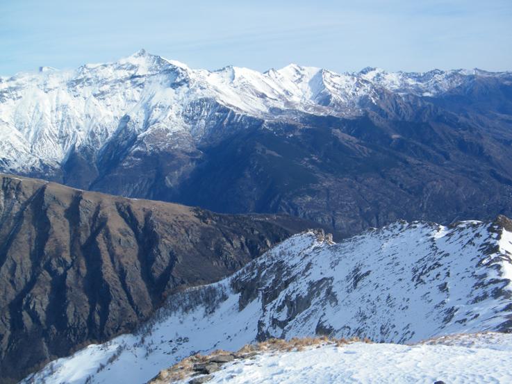
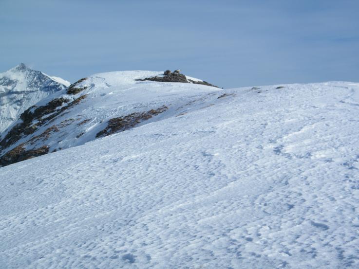
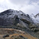
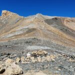
Attraversare la bella borgata per raggiungere la Chiesa posta all’estremità Est dell’abitato. Sulla sinistra dell’edificio una breve “salitella” conduce alla strada soprastante che va alle Grange della Valle (cartello). Seguirla per tale direzione (strada sterrata dopo pochi metri) fino a quando i segnavia portano su un sentierino che in breve raggiunge la località Grange Catube, m. 1422 (se non si rinvengono i segnavia, la strada conduce comunque a Grange Catube). Seguendo sempre la sterrata si incontra poco dopo la deviazione a destra per le Grange Clot di Brun (cartello e sbarra) che si raggiungono senza mai abbandonare la carrareccia che si dipana dolcemente attraverso un bellissimo bosco misto all’inizio e poi di resinose. In alternativa, dai pressi del cartello, si può seguire un sentiero, evidente ma non segnalato, che con un lungo diagonale ascendente permette di abbreviare decisamente il percorso. Raggiunte le Grange Clot di Brun, m. 1905, all’estremità destra dell’alpeggio, là dove sono presenti le indicazioni per il “Pertus di Romean” e “Quattro Denti” (direzione Est), seguire una marcata traccia che si alza nel rado e ripido bosco verso Nord. Giunti al suo limitare (m. 2100 circa), si perviene ad un’ampia radura frutto di attività valanghiva, dove la traccia si perde un po’ (visibili in alto sulla destra le recinzioni para valanghe della Cresta dei Quattro Denti). Da qui in poi si procede su terreno aperto. Attraversare l’ampia radura con un diagonale ascendente facendo un semicerchio con direzione N/NE – N/NW (qualche ometto) o, in alternativa, puntare direttamente verso l’alto sulla massima pendenza all’uscita del bosco, fino a rinvenire nuovamente la traccia su terreno aperto la quale, con costante direzione N/NW porta dolcemente in prossimità di una evidente “palificata” a sostegno del pendio (m. 2380 circa). Qui la traccia molto evidente volge verso Est conducendo in breve alla poco marcata depressione posta ad Ovest della Cima del Vallone, raggiungibile percorrendo la facile e panoramica cresta (croce e resti delle fortificazioni della Battaglia del Vallone del 1711 in vetta).
Ritorno: per evitare il lungo spostamento dalle Grange Clot di Brun alle Gr. Catube, poco sotto le prime, imboccare sulla carrareccia, a sinistra, il sentiero per Case Armeita (palina) che, con percorso diretto, taglia per il bosco la sterrata velocizzando notevolmente il percorso. Tale opzione vale ovviamente anche per l’andata individuando la segnaletica CAI bianco/rossa posta sui tronchi.
- Cartografia:
- I.G.C. 1:50000 n.1 Valli di Susa, Chisone e Germanasca
Nelle vicinanze Mappa
Itinerari
15/10/2023 TO, Exilles D+ 1100 m E Varie
Chabriere (Monte) da San Colombano per Grange della Valle
 50m
50m
29/05/2022 TO, Exilles D+ 1700 m E Nord
Assietta (Testa dell’) da Exilles
 1.6Km
1.6Km
11/11/2007 TO, Salbertrand D+ 1410 m EE Varie
Galambra (Passo) da Selle Marre, anello per il Monte Chabriere e Casses Blanches
1.8Km
25/09/2022 TO, Salbertrand D+ 659 m E Sud
Levi-Molinari (Rifugio) e Grange della Valle da Combes
 2Km
2Km
22/10/2023 TO, Exilles D+ 900 m E Est
Monache (Cima delle) e quota 2637 m da Grange della Valle
 2.3Km
2.3Km
19/09/2025 TO, Exilles D+ 1600 m EE Sud-Est
Gros Muttet da Grange della Valle per il Rifugio Vaccarone, anello
 2.3Km
2.3Km
19/09/2025 TO, Exilles D+ 1750 m EE/F Varie
Ambin (Rocca d’) da Grange della Valle per il Rifugio Vaccarone, anello
 2.3Km
2.3Km
12/09/2021 TO, Exilles D+ 1200 m EE Tutte
Vaccarone Luigi (Rifugio) da Gange della Valle, anello per Passo Clopaca e Cima Quattro Denti
 2.3Km
2.3Km
13/07/2026 TO, Exilles D+ 2500 m E Tutte
Vaccarone, Levi-Molinari, Ambin, Petit Mont Cenis (Rifugi) da Salbertrand, Tour dell’Ambin
2.3Km
05/07/2026 TO, Exilles D+ 1483 m EE Sud
Sommeiller (Punta) da Grange della Valle
 2.3Km
2.3Km
Servizi
1.3Km
1.3Km
L’ultima stisa Ristorante
Exilles
1.4Km
Touplan Ristorante
Exilles
3Km
Levi Molinari Rifugio
Exilles
5Km
Arlaud Rifugio
Salbertrand
5Km
Il Covo di nord ovest Ristorante
Salbertrand
5.2Km
Casa Assietta Rifugio
Pragelato
5.9Km
Vaccarone Rifugio
Giaglione
7.3Km
Jamais sans tois Ristorante
Chiomonte
7.3Km


