 3.2Km
3.2Km
Note
 350m
400m
400m
600m
1Km
1.1Km
2Km
2.9Km
2.9Km
350m
400m
400m
600m
1Km
1.1Km
2Km
2.9Km
2.9Km
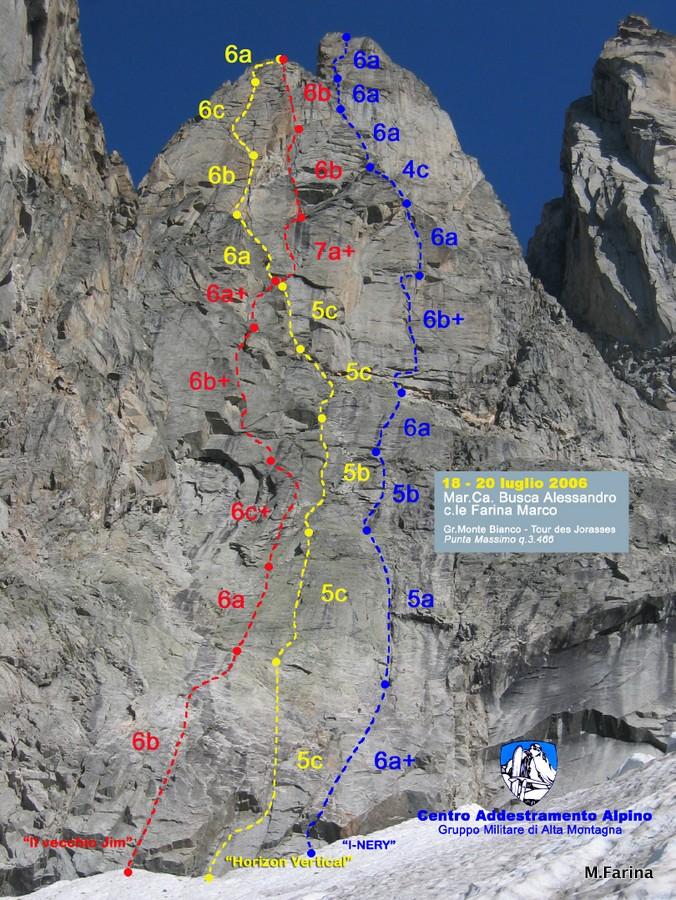
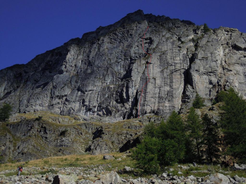
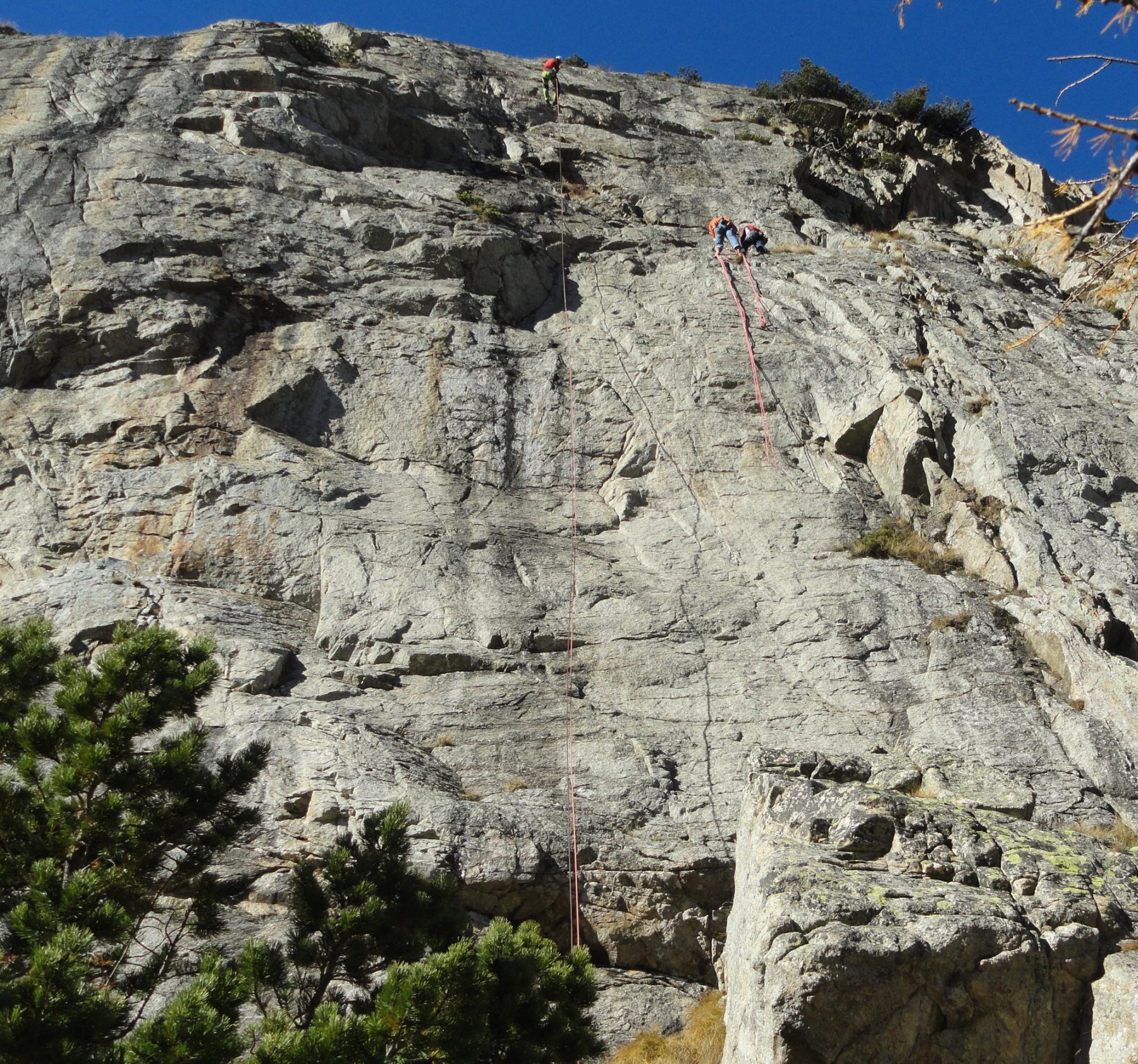
E' il gran pilier che sorregge le jorasses. Itinerario aperto nel 71 da Machetto Calcagno Cerutti.
Attenzione alle scariche di sassi del canale a sx per arrivare all'attacco.
Avvicinamento
Attenzione alle scariche di sassi del canale a sx per arrivare all'attacco.
,
Descrizione
Dal rif Boccalatte si scende sul ghiacciaio delle Jorasses e lo si risale (a sx, più diretto ma crepacciato o a dx più lungo ma sicuro) in direzione del pilier riconoscibile per essere composto da due cime.
Avvicinamento circa 1’45”.
L’attacco è a sx di Etoiles filantes su una cengia sopra un canale nevoso.
Si obliqua a sx per le prime tre lunghezze per poi puntare al gran diedro che si scala a sx. Friend fino al 4 (doppio), martello, cordini per le soste.
Discesa in doppia sulla via o su Etoiles Filantes.
Dalla sosta 12 si può raggiungere la vetta con altri 300 mt più facili.
- Bibliografia:
- Buscaini M Bianco - Bassanini Le classiche
Nelle vicinanze Mappa
Itinerari
21/07/2012 AO, Courmayeur 7a, 6b obbl. Sud-Est
Jorasses (Tour des), quota 3466 m o Punta Massimo – Il Vecchio Jim
 350m
350m
13/06/2026 AO, Courmayeur 7b, 6c obbl. Sud-Est
Jorasses (Tour des) – Etoiles Filantes
 400m
400m
21/08/2021 AO, Courmayeur 6c, 6b obbl. Sud-Est
Jorasses (Tour des), quota 3466 m o Punta Massimo – Horizon Vertical
 400m
400m
14/06/2026 AO, Courmayeur 6b+, 6a+ obbl. Sud-Est
Jorasses (Tour des), quota 3466 m o Punta Massimo – I-Nery
 600m
600m
01/07/2018 AO, Courmayeur 6b+, 6a obbl. Sud-Ovest
Eveque (Aiguille de l’) – Les Pèlerins et la Dame
 1Km
1Km
20/09/2019 AO, Courmayeur 6b+, 6a obbl. Sud
Jorasses (Tour de), sperone sud – Lezioni di Piano
 1.1Km
1.1Km
21/07/2013 AO, Courmayeur 7b+, 7a+ obbl. Sud-Est
Jorasses (Tour des) – Abysse
1.2Km
09/08/2011 AO, Courmayeur 7a, 6c obbl. Sud
Eveque (Aiguille de l’), pilastro – Straordinaria
 2Km
2Km
07/07/2024 AO, Courmayeur 6a+, 5c obbl. Sud
Salluard Franco (Pilastro) – Il Gatto e la Volpe
 2.9Km
2.9Km
14/06/2026 AO, Courmayeur 7b, 6c obbl. Sud
Petites Jorasses – Pantagruel
 2.9Km
2.9Km