 100m
100m
Note
 50m
50m
50m
50m
50m
50m
50m
2Km
50m
50m
50m
50m
50m
50m
50m
2Km
100m
100m
150m
1.9Km
3.4Km
6.2Km
6.9Km
6.9Km
6.9Km
6.9Km
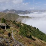
Traversata da compiere in tre giorni dormendo nei bivacchi della zona.
Avvicinamento
.,
Descrizione
Da Bousson (Cesana) salire in auto per Thures, poi continuare fino alla località Rhuilles
Parcheggiare subito dopo il paese. Da qui salire alla grange Thuras superiori, poi continuare a risalire la valle seguendo la strada e poi il sentiero per il colle di Thuras. Dove si trova il Bivacco Tornior, comodo per il pernottamento
Il giorno seguente ci si dirige per il colle della Ramiere, il sentiero diventa più continuo e anche segnalato con bolllini gialli. Raggiunti gli sfasciumi sotto il colle, il sentiero diventa più ripido e rapidamente si raggiunge il colle della Ramiere m.3007 (casermetta nei pressi).
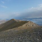
Da qui, sempre percorrendo un evidente sentiero prendere a destra e salire prima per cresta, poi per sfasciumi di varia grandezza fino a raggiungere la vetta, costituita da una lunga cresta, con una croce ad una estermità. Discesa per le evidenti tacce gialle in valle Argentera e poi per EPT 612.
Si sale verso le Grange Clotes, seguendo le tracce di sentiero (bolli gialli); in alternativa, si seguono i paletti lignei con bolli sbiaditi bianco-rossi che permettono di prendere quota velocemente fra pratoni senza percorso obbligato. Finché si reperisce la “sede” del sentiero (609), che compie un lungo traverso ascendente (direzione nord est), attraversando diversi torrenti e sorgive e guadagnando il bel costone sud-ovest del Monte Appenna in prossimità del bivio con un sentiero, che dovrebbe pervenire dalla Valle Lunga. Si prosegue per il costone, finché il sentiero punta in direzione del Col Clapis (direzione nor-ovest), raggiuntolo, da questo per traccia (direzione sud-est) si arriva alla cima al Monte Appenna. Ridiscendendo al Colle Clapis si scende ora per la Val Troncea e a pochi minuti si trova il Casotto Clapis (chiuso a chiavi e gestito dal parco della valle, per le chiavi occorre sentire l’ufficio del parco della Val Troncea).
Dopo pernottamento al mattino si ridiscende per il sentiero 319 fino alla strada di fondovalle che ci riporta a Pragelato.
- Cartografia:
- IGC carta n° 1 Valli di Susa Chisone e Germanasca
Nelle vicinanze Mappa
Itinerari
07/09/2025 TO, Cesana Torinese D+ 1300 m E Nord
Dormillouse (Cima) e Bivacco Matteo Corradini da Rhuilles
 50m
50m
23/07/2023 TO, Cesana Torinese D+ 564 m E Nord-Est
Chabaud (Colle) da Rhuilles
 50m
50m
26/04/2011 TO, Cesana Torinese D+ 750 m EE Est
Corbioun (Monte) da Rhuilles per il Colle Begino
 50m
50m
16/08/2022 TO, Cesana Torinese D+ 1027 m EE Nord-Est
Dorlier (Cima) da Rhuilles per il Monte Giassiez
 50m
50m
21/06/2020 TO, Cesana Torinese D+ 840 m EE Sud-Est
Fournier (Cima) da Rhuilles, anello per Col Chabaud, Colle Begino, Roche Courbe
 50m
50m
09/08/2025 TO, Cesana Torinese D+ 856 m E Nord
Giassiez (Monte) o Giaissez da Rhuilles
 50m
50m
18/08/2025 TO, Cesana Torinese D+ 1443 m EE Varie
Terra Nera (Monte) da Rhuilles, anello per i monti Giaissez, Dorlier, Dormillouse e Vallone Clausis
 50m
50m
03/09/2023 TO, Cesana Torinese D+ 1288 m EE Nord-Ovest
Dormillouse (Cima) da Rhuilles, anello per Monte Giaissez e Cima Dorlier
50m
21/08/2015 TO, Cesana Torinese D+ 1800 m EE Nord
Thuras, Rasis, Malrif, Chabaud (Colli) da Rhuilles, anello per les Fonts
50m
11/09/2023 TO, Cesana Torinese D+ 1200 m EE/F Varie
Furgon (Monte) da Thures
 2Km
2Km
Servizi
100m
100m
La Tana degli Orsi B&B
Cesana Torinese
150m
La Crota B&B
Cesana Torinese
1.9Km
La Fontana del Thures Rifugio
Cesana Torinese
3.4Km
Centro Ristorante
Cesana Torinese
6.2Km
Misun La Font Ristorante
Sauze di Cesana
6.9Km
L’Ibarus Rifugio
Cesana Torinese
6.9Km
Piergiorgio Frassati B&B
Cesana Torinese
6.9Km
Casa Cesana Bar
Cesana Torinese
6.9Km


