 1.8Km
1.8Km
Note
Storico
 400m
1.2Km
1.4Km
1.8Km
2.1Km
3Km
3.5Km
3.8Km
5.9Km
6Km
400m
1.2Km
1.4Km
1.8Km
2.1Km
3Km
3.5Km
3.8Km
5.9Km
6Km
1.8Km
5Km
5.7Km
6.7Km
6.7Km
7.2Km
8.4Km
8.5Km
8.5Km
10Km
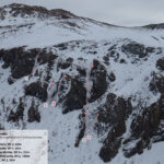
Le cascate:
- n.171 Cascata di Pisse Neire (Cascatone della Banchetta)
- n.172 Il cilindro dei magnifici sette
- n.173 Cascata della Guglietta
- n.174 Cascata della Grande
- n.175 Cascata la Piccola
sono vietate dato che è zona di nidificazione dell'aquila. I guardiaparco del Parco Val Troncea non mancheranno di controllarvi. Le sanzioni sono molto pesanti. Informarsi c/o i guardiaparco per eventuali variazioni ai divieti.
Avvicinamento
- n.171 Cascata di Pisse Neire (Cascatone della Banchetta)
- n.172 Il cilindro dei magnifici sette
- n.173 Cascata della Guglietta
- n.174 Cascata della Grande
- n.175 Cascata la Piccola
sono vietate dato che è zona di nidificazione dell'aquila. I guardiaparco del Parco Val Troncea non mancheranno di controllarvi. Le sanzioni sono molto pesanti. Informarsi c/o i guardiaparco per eventuali variazioni ai divieti.
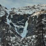
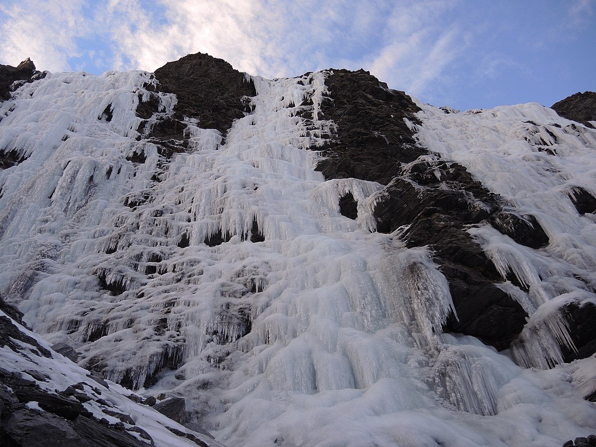
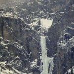
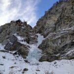
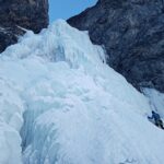
Si risale la Val Troncea, raggiunta la fontana Landeniera (m 1970) traversato il torrente lasciare a dx la bergeria omonima per risalire il canalone verso il cascatone del Rouit. Oltrepassatolo, si continua per prati e in breve si è alla base (h. 2,30).
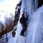
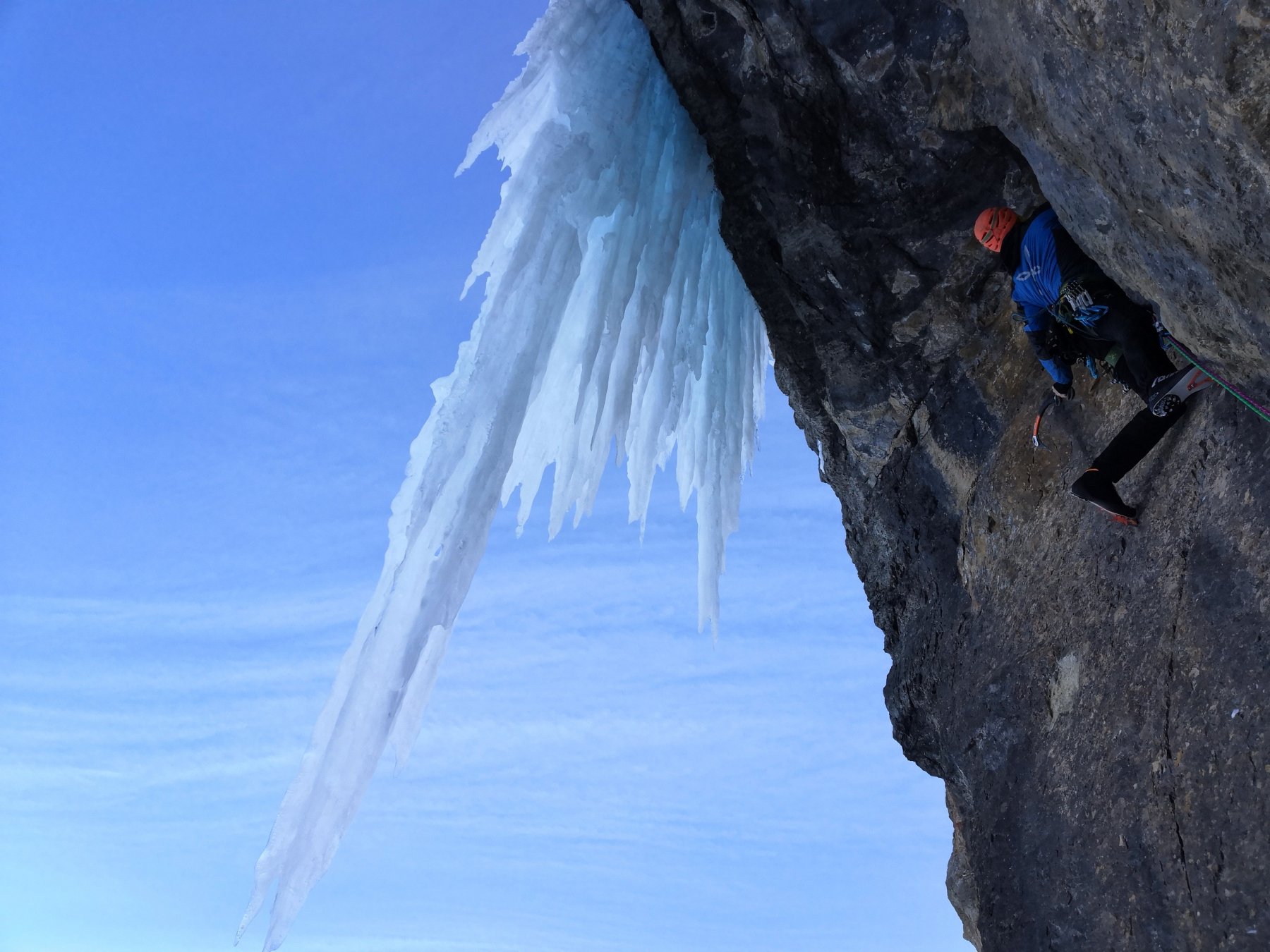
Descrizione
1°tiro 50m 80/85°
2°tiro candela 35m 90/95°
Discesa sulla destra orografica:dall’uscita risalire il canale per circa 80m,traversare a sinistra un costolone e raggiungere un larice posto sopra un salto roccioso.
Con una doppia di 25m raggiungere il canale che riporta all’attacco.
G.C. Grassi, S. Rossi e P. Marchisio il 12.1.88
- Bibliografia:
- Ghiaccio dell'Ovest - G.C.Grassi
Nelle vicinanze Mappa
Itinerari
10/01/2026 TO, Pragelato 130 m III, 4 Est
Val Troncea – Rouit (Cascatone del)
 400m
400m
24/01/2026 TO, Pragelato 100 m IV, 4+ Est
Val Troncea – Platasse (Cascata della)
 1.2Km
1.2Km
27/02/1994 TO, Pragelato 150 m III, 4+ Nord-Est
Val Troncea – Guglietta (Cascata della) VIETATA
 1.4Km
1.4Km
15/12/2024 TO, Pragelato 100 m IV, 5 Est
Val Troncea – Lacrime Ibernate (Cascata)
 1.8Km
1.8Km
05/01/2025 TO, Pragelato 120 m III, 4 Sud-Est
Val Troncea – Paretone del Rio Faurì (Cascate)
 2.1Km
2.1Km
21/02/1995 TO, Pragelato 120 m IV, 5 Nord-Est
Val Troncea – Pisse Neire (Cascata) VIETATA
 3Km
3Km
31/12/2018 TO, Sestriere 65 m III, 5+, M8 Nord
Banchetta (Monte) – Alla Bellemmeglio (Cascata)
 3.5Km
3.5Km
16/12/2023 TO, Sestriere 180 m III, 2 Ovest
Chisonetto (Vallone del) – Principiante e dei Tre (Cascate)
 3.8Km
3.8Km
21/12/2025 TO, Sauze di Cesana 100 m II, 2+ Nord-Est
Valle Argentera – Rio Guccie (Cascata del)
 5.9Km
5.9Km
11/01/2025 TO, Sauze di Cesana 50 m III, 3+ Nord
Valle Argentera – Rio Adriet (Cascata del)
 6Km
6Km
Servizi
1.8Km
5Km
Mulino di Laval Rifugio
Pragelato
5.7Km
Refugium – ex. Rif. Belotte Rifugio
Pragelato
6.7Km
La capanna del sole Ristorante
Pragelato
6.7Km
Al Mulino Ristorante
Pragelato
7.2Km
Misun La Font Ristorante
Sauze di Cesana
8.4Km
Casa degli Escartons Alex Berton B&B
Pragelato
8.5Km
Casa Alpina Rifugio
Pragelato
8.5Km
Passet Ristorante
Pragelato
10Km


