 6.2Km
6.2Km
Note
 50m
50m
50m
50m
50m
50m
50m
50m
50m
50m
50m
50m
50m
50m
50m
50m
Viene descritta la traversata del col De Miage anche se abitualmente si raggiunge il colle per poi salire l'Aiguille de Bionassay.
L'itinerario è lungo (vi è l'opportunita di spezzarlo in 2 giornate dormendo al Durrier.
L'ambiente è veramente grandioso e selvaggio ed anche parecchio pericoloso nell'ultima parte sul lato italiano.Occorre partire molto presto la notte se si vuol ridurre il rischio di caduta seracchi e pietre in prossimita del colle.
Prevedere di lasciare una macchina al Piazzale delle funivie di La Palud per tornar a recuperare l'altra.
Avvicinamento
L'itinerario è lungo (vi è l'opportunita di spezzarlo in 2 giornate dormendo al Durrier.
L'ambiente è veramente grandioso e selvaggio ed anche parecchio pericoloso nell'ultima parte sul lato italiano.Occorre partire molto presto la notte se si vuol ridurre il rischio di caduta seracchi e pietre in prossimita del colle.
Prevedere di lasciare una macchina al Piazzale delle funivie di La Palud per tornar a recuperare l'altra.
.
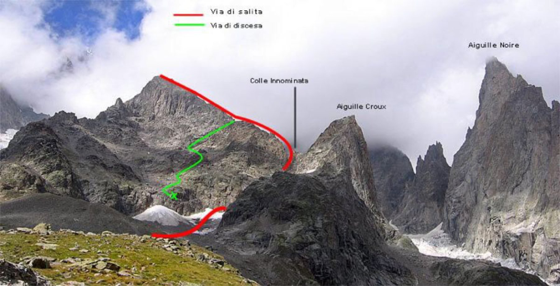
Descrizione
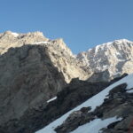
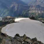
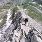
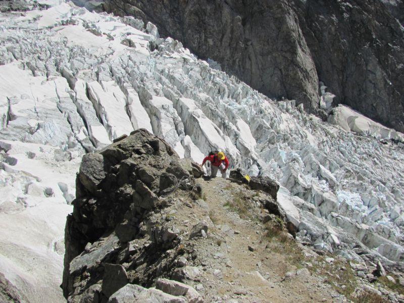
Da La Visaille dove si parcheggia le macchina si sale fino al Combal. Da qui risalire la morena del Miage fino a posar piede sul ghiacciaio coperto e seguire le poche tracce per il Gonella. Quando le tracce piegano verso il costone dove sorge il rifugio noi si continua a salire dritti puntando l’evidente colle. Nel giro di poco si calzano i ramponi e si risale il ghiacciaio di Bionassay, circumnavigando grandi crepacci, fino ad arrivare sotto la barra rocciosa che divide l’alto ghiacciaio del Miage. Si attacca la parete alta una 50 di metri nel punto che sembra un po migliore (quest’anno bisognava calarsi dentro la terminale e poi risalire); roccia ottima e qualche passo di 3+.
Usciti dalla fascia di rocce cercare di mettersi il più possibile al riparo dalla traiettoria dei seracchi e dei couloir di pietre delle coste sommitali. Risalire il ripido ghiacciaio fino a dove i seracchi vanno a chiudere la via. Da qui si può scegliere se traversare e risalire lungo le rocce di destra o entrare tra i canali dei seracchi (50°)Una volta passata questa fascia si raggiunge un ultimo pendio che porta al colle dove è posto il Rifugio.6-7H partire non oltre le 4
La discesa parte subito su un costone di rocce rotte e instabili, molto ripido e con zero punti di assicurazione. Si perde rapidamente quota fin a recuperare velocemente una traccia che ci porta a dover attraversare in piano il glacier du Miage puntando un evidente dollo rosso sulla parete opposta dove delle corde fisse ci permettono di superare il costone. Ora un buon sentiero che attraversa grandi nevai ed è facilitato da numerose corde fisse ci porta fino al Plan de l’Aigle. Seguendo un sentiero molto ripido d’apprima su morena poi su boschetti radi si raggiunge Lo Chalet du Miage e da qui con una poderale si discende fino al fondovalle a metà strada tra Le Contamine e St.Gervais les bain. Con il bus o autostop si raggiunge St. Gervais e da qui o col bus o con treno Chamonix dalla quale si prende la navetta che riporta a Courmayeur.
Per la discesa calcolare almeno 5 ore quidi o si decide di effettuare la traversata con comodo in 2 giorni o essere ben allrnati
Nelle vicinanze Mappa
Itinerari
16/07/2026 AO, Courmayeur D+ 2100 m D Ovest
Innominata (Punta) Via del CAI di Tortona
 50m
50m
08/07/2022 AO, Courmayeur D+ 1600 m PD Sud
Croux (Aiguille) Cresta Sud
 50m
50m
18/06/2026 AO, Courmayeur D+ 2162 m AD Sud-Est
Innominata (Punta) Cresta Est
 50m
50m
30/07/2017 AO, Courmayeur D+ 1922 m F Varie
Glaciers (Dome des) da La Visaille per il Rifugio Elisabetta
 50m
50m
22/08/2008 AO, Courmayeur D+ 1300 m TD+ Sud-Ovest
Gugliermina (Pic) Via Gervasutti – Boccalatte
50m
20/09/2025 AO, Courmayeur D+ 1754 m F Sud-Est
Piccolo Monte Bianco o Petit Mont Blanc da La Visaille
 50m
50m
10/08/2025 AO, Courmayeur D+ 1000 m PD Nord-Est
Pyramides Calcaires, cima SE – Cresta NE
 50m
50m
30/07/1978 AO, Courmayeur D+ 2300 m AD Nord
Trelatete orientale (Aiguille de) dal versante Sud per il ghiacciaio sospeso
50m
18/08/2021 AO, Courmayeur D+ 1300 m F+ Sud
Gonella Francesco (Rifugio) al Dome da La Visaille
 50m
50m
05/08/2025 AO, Courmayeur D+ 2200 m D Sud
Glaciers (Aiguille des) Cresta SE via Kuffner
 50m
50m