 3.7Km
3.7Km

Note
 700m
3.9Km
4.5Km
4.5Km
4.5Km
5.7Km
700m
3.9Km
4.5Km
4.5Km
4.5Km
5.7Km
3.7Km
3.8Km
3.8Km
4.8Km
5.7Km
5.7Km
6.5Km
7Km
7.1Km
8.3Km
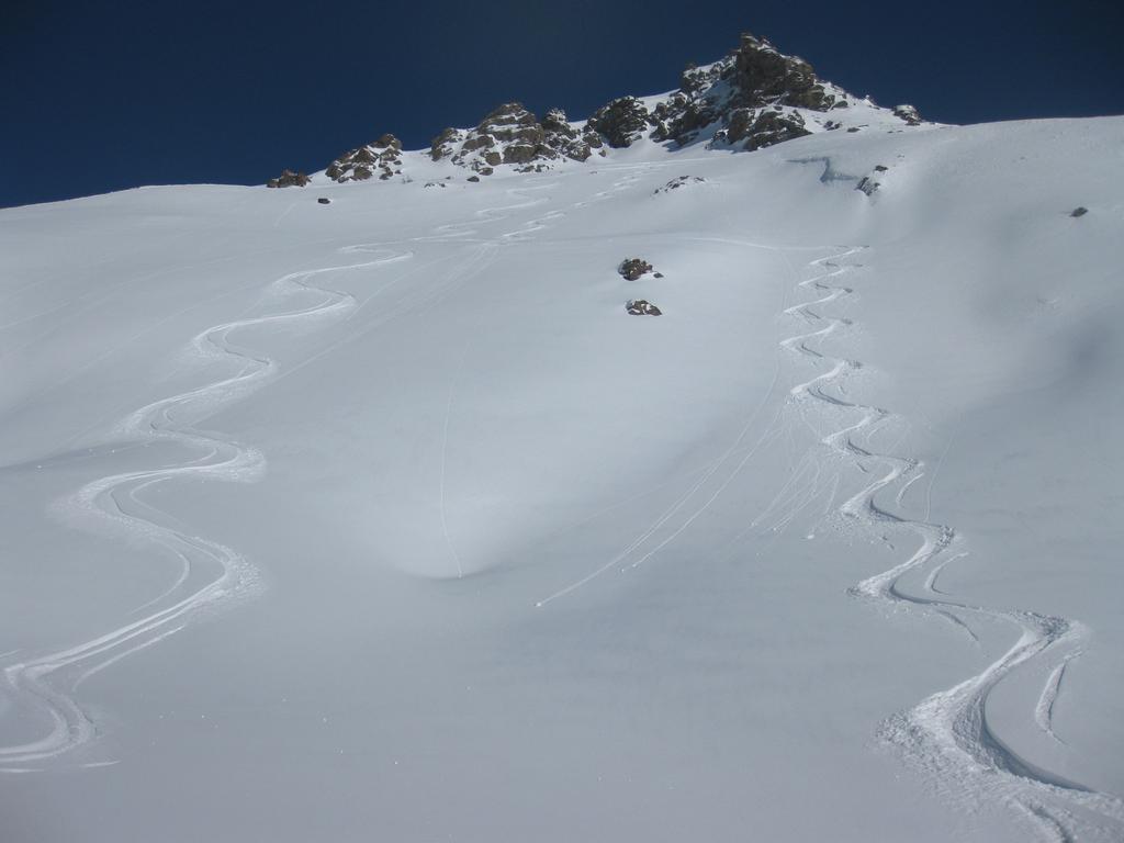
Bellissimo fuoripista, molto lungo, considerando la posssibilità di risalire con gli impianti. Un po' in traverso.
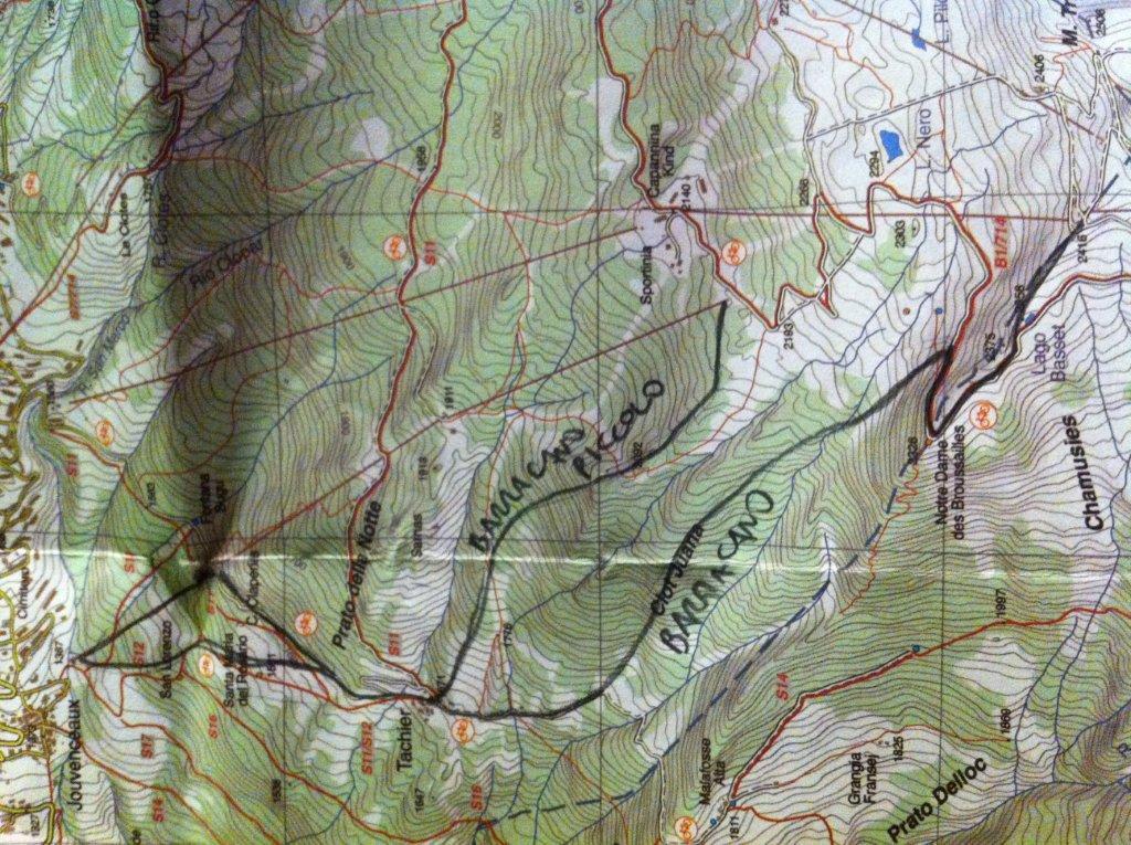
Descrizione
Dall’ arrivo della Seggiovia Rocce Nere di Sportinia (2419 m), seguire la stradina in prossimità della cresta che raggiunge Notre Dame des Broussailles (2326 m) e che compie un tornante sul costone. Proseguire ancora un tratto sulla stradina e quindi a piacere introno ai 2300 m “buttarsi giù” ed entrare nel bosco rado.
Si costeggia brevemente la pista 12 alta per poi inoltrarsi nel bosco fitto della Clot Juana, la parte più interessante del fuoripista, dove si alternano bei pendii a brevi traversi, piuttosto logici…specie seguendo le tracce.
Si incontra una vecchia pista che non so individuare (forse “Malafosse” o “12 media”) e si perviene infine al bel paesino di Tachier (1672 m), dove la parte più interessante finisce.
Di qui imboccare la stradina che riporta verso Sauze e scegliere fra le 3 alternative che nell’ ordine si presentano:
1) Subito a sinistra per un traverso nei prati
2) imboccare la pista 12 bassa (ma non ne sono sicuro) se non battuta
3) Scendere sotto la seggiovia se non é troppo tracciato.
Si arriva comodamente alla partenza della seggiovai Jovenceuax-Sarnas
- Cartografia:
- Fraternali N°2, IGC N°1 -Valli di Susa, Chisone e Germanasca
Nelle vicinanze Mappa
Itinerari
22/12/2012 TO, Sauze D'oulx D+ 1110 m 3.2, E1 Nord-Ovest
Rio Nero
 700m
700m
17/03/2013 TO, Sauze D'oulx D+ 580 m 3.2, E1 Nord
Sportinia-Prariond
2Km
24/12/2025 TO, Sestriere D+ 1000 m 3.1, E1 Nord
Sestriere Boschi
 3.9Km
3.9Km
12/03/2013 TO, Sestriere D+ 595 m 3.1, E1 Sud-Est
Basset (Col) dal Fraiteve
4.5Km
14/02/2018 TO, Sestriere D+ 720 m 3.2, E1 Ovest
Grangesises dal Sises
 4.5Km
4.5Km
22/12/2012 TO, Sestriere D+ 580 m 3.2, E1 Sud-Ovest
Sises (Monte) discesa a Bessen Haut
 4.5Km
4.5Km
23/01/2015 TO, Sestriere 3.1, E1 Varie
Sestriere Pali della luce, Sotto Rognosa, Colombiere
 4.5Km
4.5Km
23/12/2016 TO, Pragelato D+ 1000 m 3.1, E1 Nord
Pragelato Fuoripista Vari
 5.7Km
5.7Km
01/12/2012 TO, Sestriere D+ 540 m 1.1, E1 Sud
Chalmettes – Rollieres da San Sicario
6.1Km
08/12/2012 TO, Sauze di Cesana D+ 940 m 3.1, E1 Sud
Roccia Rotonda da Sansicario
6.3Km
Servizi
3.7Km
3.8Km
paddy mc ginty Ristorante
Sauze d'Oulx
3.8Km
orto del frate Ristorante
Sauze d'Oulx
4.8Km
La Moretta Ristorante
Oulx
5.7Km
Al Mulino Ristorante
Pragelato
5.7Km
La capanna del sole Ristorante
Pragelato
6.5Km
La Chardouse Rifugio
Oulx
7Km
Mulino di Laval Rifugio
Pragelato
7.1Km
Misun La Font Ristorante
Sauze di Cesana
8.3Km


