 2.4Km
2.4Km
Note
 1.7Km
2.9Km
3Km
3Km
3Km
3.1Km
10.4Km
10.4Km
10.4Km
1.7Km
2.9Km
3Km
3Km
3Km
3.1Km
10.4Km
10.4Km
10.4Km
2.4Km
2.4Km
2.4Km
4.1Km
5.6Km
6.4Km
9.1Km
9.1Km
9.1Km
9.2Km
In Val Thuras esiste una cima secondaria chiamata Guglia Rossa, sul costone che si stacca dal Roc del Boucher, sulla sinistra idrografica del Vallone della Musia. Tale cima rocciosa, alta 2478 m sembra offrire qualche possibilità di arrampicata ed é indicata su molte cartine. La GMI definisce invece "Guglia Rossa", un obelisco di roccia lato 8-10 sul versante opposto, destra idrografica del Vallone della Musia e lo definisce come "di forma ardita e certo di non facile scalata". L' itinerario seguente descrive questa seconda guglia.
Avvicinamento
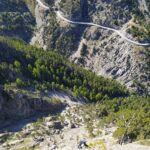
SS24 del Monginevro fino a Cesana Torinese, oppure A32 uscita Oulx circonvallazione quindi Cesana. Da Cesana si sale verso Sauze di Cesana fino a trovare a destra, poco oltre Bousson, la deviazione per Thures. Giunti a Thures proseguire sullo sterrato senza entrare nell'abitato, in direzione di Rhuilles, quindi proseguire fino al fondo della piana dove si prosegue, con autovetture adatte ed a seconda delle condizioni del fondo, sulla ex strada militare che con tratti ripidi conduce alle grange Thuras inferiori, dove si posteggia poco prima del ponte.
ATTENZIONE: dal 2025 non è possibile proseguire oltre Rhuilles, a causa dell'inagibilità del Ponte Ciatagnera. Occorre pertanto salire alla a Thures, e proseguire sulla sterrata che passa per la località Gorlier, per poi scendere a Rhuilles già oltre il ponte e ricollegarsi con l'accesso normale al vallone. Questo percorso alternativo è consigliabile con 4x4 o vetture alte.
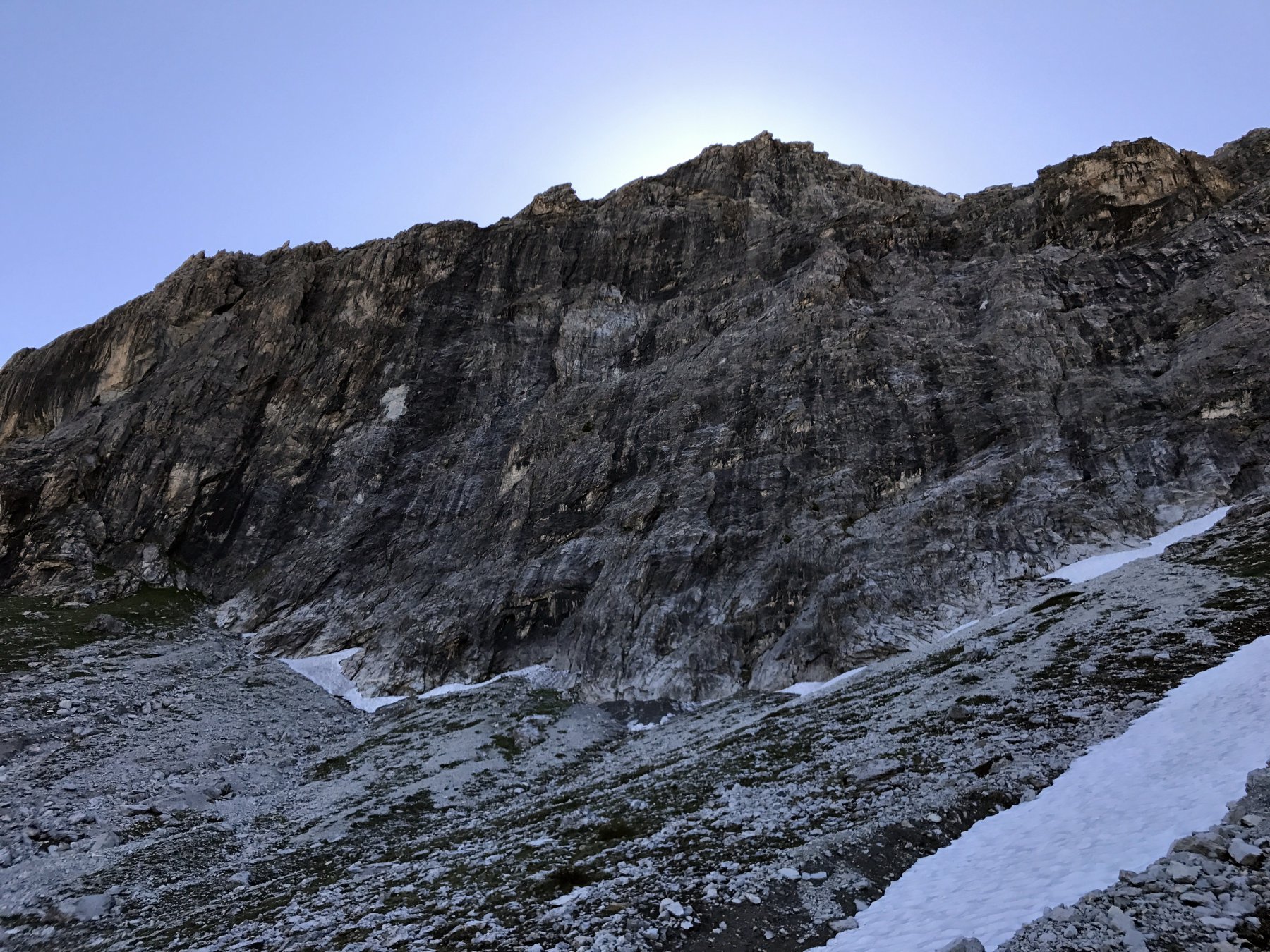
Si risale sulla sinistra (dx orografia) il Vallone della Musia, tenendosi in prossimità del torrente. Il percorso é molto bello per il tipo di roccia levigata e le numerose pozze e cascatelle (più grosse a inizio stagione). Nell' ultimo tratto si gira a sinistra verso un costone erboso, risalendo prati e qualche pietraia molto ripidi. Il monolite, essendo piuttosto piccolo, non si individua da molto lontano, ma essendo unico, isolato e rosso é poi faile da raggiungere.
Descrizione
ATTENZIONE: dal 2025 non è possibile proseguire oltre Rhuilles, a causa dell'inagibilità del Ponte Ciatagnera. Occorre pertanto salire alla a Thures, e proseguire sulla sterrata che passa per la località Gorlier, per poi scendere a Rhuilles già oltre il ponte e ricollegarsi con l'accesso normale al vallone. Questo percorso alternativo è consigliabile con 4x4 o vetture alte.
Si risale sulla sinistra (dx orografia) il Vallone della Musia, tenendosi in prossimità del torrente. Il percorso é molto bello per il tipo di roccia levigata e le numerose pozze e cascatelle (più grosse a inizio stagione). Nell' ultimo tratto si gira a sinistra verso un costone erboso, risalendo prati e qualche pietraia molto ripidi. Il monolite, essendo piuttosto piccolo, non si individua da molto lontano, ma essendo unico, isolato e rosso é poi faile da raggiungere.
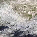
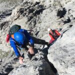
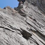
La via più semplice “normale”, é quella più breve dello spigolo che parte dal punto più alto del pendio da cui si stacca il monolite. Oppone difficoltà di IV, e poi gli ultimi 2 metri forse V, con un traverso a sinistra o un tratto leggermente stapiombante sulla linea. in ogni caos gli ultimi 2 metri non sono stati scalati.
Non vi é attrezzatura, ma tutto il monolite sembra offrire possiblità di scalata; lo spigolo opposto a quello descritto sembra anch’ esso abbastanza abbordabile. Complessivamente per gli amanti del genere potrebbe essere un cimento interessante
- Cartografia:
- Fraternali N°2, IGC N°1 -Valli di Susa, Chisone e Germanasca
- Bibliografia:
- GMI - Alpi Cozie centrali - itinerario 683 pag. 387
Nelle vicinanze Mappa
Itinerari
05/07/2026 TO, Cesana Torinese 5b, 5a obbl. Nord
Alberon (Cima) – Voie de l’Amitiè
 1.7Km
1.7Km
21/07/2022 TO, Cesana Torinese 6a, 5c obbl. Nord-Ovest
Furgon (Monte) Parete NO – Furgon Plaisir
 2.9Km
2.9Km
07/09/2024 TO, Cesana Torinese 6c, 5a obbl. Nord-Ovest
Furgon (Monte) – Via del Pilastro
 3Km
3Km
05/09/2022 TO, Cesana Torinese 6c+, 6a+ obbl. Nord-Ovest
Furgon (Monte) – Polvere di Stelle
 3Km
3Km
14/06/2025 TO, Cesana Torinese 6b+, 6a+ obbl. Nord-Ovest
Furgon (Monte) – Super Furgon
 3Km
3Km
24/06/2012 TO, Cesana Torinese 6b+, 6a+ obbl. Nord-Ovest
Furgon (Monte) – Avventura Verticale
 3.1Km
3.1Km
20/07/2013 TO, Cesana Torinese 6a+, 5c obbl., a0 Nord-Ovest
Clarì (Rocca) – Placche Nere
10.3Km
28/06/2026 TO, Cesana Torinese 7a, 6a+ obbl. Ovest
Clarì (Punta) – Un Pas Vers le Ciel
 10.4Km
07/07/2026 TO, Cesana Torinese 6b, 5c obbl. Nord-Ovest
Clarì (Rocca) – Rodèo sur Juliette
 10.4Km
18/07/2026 TO, Cesana Torinese 6a+, 6a obbl. Nord-Ovest
Clarì (Rocca) – Super Calcaire
 10.4Km
Servizi
2.4Km
2.4Km
La Tana degli Orsi B&B
Cesana Torinese
2.4Km
La Crota B&B
Cesana Torinese
4.1Km
La Fontana del Thures Rifugio
Cesana Torinese
5.6Km
Centro Ristorante
Cesana Torinese
6.4Km
Misun La Font Ristorante
Sauze di Cesana
9.1Km
L’Ibarus Rifugio
Cesana Torinese
9.1Km
Piergiorgio Frassati B&B
Cesana Torinese
9.1Km
Casa Cesana Bar
Cesana Torinese
9.2Km

