3.3Km
3.3Km
Note
 3.4Km
3.4Km
3.4Km
3.4Km
3.4Km
3.4Km
3.4Km
3.4Km
3.4Km
3.4Km
3.3Km
3.3Km
3.4Km
5Km
5.1Km
5.8Km
6.1Km
8.8Km
9.6Km
9.6Km
E' un giro veramente divertente adatto ad ogni bikers in quanto non ha difficoltà particolari.
Avvicinamento
.
Descrizione
Si parte da Sommarese, piccolo villaggio nel comune di Emarese ( da St-Vincent ca 13 km ) dal piccolo parcheggio a disposizione in centro al villaggio sulla strada. Si svolta a sx dell’unica trattoria che c’è in zona percorrendo un piccolo strappetto in salita su asfalto di circa 80 mt e si prosegue subito su sterrato. Continuando su di esso raggiungerete la località Col di Joux, attraversate la strada asfaltata e proseguite seguendo le indicazioni “ristorante da Brean” che vi consiglio x l’ottima cucina tipica.
A fianco di esso continuate su sterrato sempre dritti evitando un bivio a sx.
Dopo ca 1 km giungerete ad un bivio sulla dx che indica la località Extrepieraz. Ora spazio alla goduria in una discesa su mulattiera da sballo divertentissima. Zero difficoltà, libera a tutti, seguitela fino in fondo e giungerete appunto ad Extrepieraz sul ciglio del torrente evancon.
Giunti quasi in fondo è stato ripristinato un sentiero (101) che taglia sopra il campeggio e quindi evita il camping ed i primi tornanti di sterrato dopo di esso. Poi si ricongiunge con lo stesso itinerario. Molto bello da fare, è una variante al percorso.
Svoltate a sx e in un attimo arrivate in mezzo al campeggio del luogo. Qui attenzione perchè su asfalto dovete svoltare a sx e non andare a dx attraversando il ponte sul torrente. La strada dopo 200 mt si trasforma di nuovo in sterrato e proseguite sempre in quella direzione in mezzo al bosco facendo qualche tornante in salita.
Arriverete ad una frazione isolata con 3 o 4 case di cui 1 è un rascard. Sulla sua sx c’è una fontana. Attraversate in mezzo la frazione e proseguite su sentiero che vi porterà dentro un bosco. Occhio a non andare a sx ma osservate bene un tracciato sulla dx in concomitanza di un pianoro. Qui c’è l’unico pezzo del tour che non è pedalabile per circa 150 mt in quanto la pendenza è elevata e il fondo molto sconnesso, però appena oltrepassato questo piccolo inconveniente si riparte divertendosi su di un sentiero tecnico in mezzo ad un bellissimo bosco.
Ora giungete ad incrociare la strada asfaltata che porta ad Antagnod, svoltate a sx, proseguite per circa 200 mt poi giù a dx di nuovo su sterrato che costeggerà il torrente fino ad un ponte sulla strada regionale che porta a Champoluc. Attraversatelo e prendete a dx su un tracciato nei prati, inizialmente poco visibile poi bello e tecnico che vi porterà fino a champoluc.
Da qui raggiungete la località St-Jacques e quando vi arrivate in essa attraversate il ponte a sx sul torrente e proseguite in direzione del Rifugio Grand Tournalin percorrendo una poderale in salita per alcuni Km. Quando vi troverete in corrispondenza di un cartello indicante il rifugio, invece di continuare sullo sterrato a dx andate a sx e percorrerete uno dei più belli itinerari panoramici della zona conosciuto con il classico nome “ru cortot”.
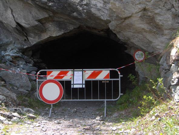
Attraverserete 2 gallerie di roccia e percorrendolo vi porterà fino ad una zona denominata Barmasc in cui vi si trova un area attrezzata ed adibita a pic nic. Da qui giù a sx su asfalto fino ad Antagnod, una volta raggiunto, al bivio svoltare a dx (a sx si va a Champoluc) e arriverete alla congiunzione con il bivio dal quale siete spuntati all’andata. (50 m prima del ponte sul torrente a dx). Ripercorretelo fino a raggiungere Brusson.
Costeggiate il lago sulla dx fino al ponte sulla regionale che porta al colle di joux. Se ne avete a sufficenza svoltate a dx su asfalto, arrivate al colle poi a sx trovate lo sterrato che vi porterà a Sommarese, altrimenti se avete ancora voglia di pedalare, quando siete al ponte svoltate a sx poi subito a dx, proseguite per 300 mt su asfalto in discesa e facendo attenzione troverete un ponticello di legno che attraversa il torrente a dx.
Svoltate e poi andate a sx su sterrato. Siete su un tracciato che con un po’ di sali scendi vi porterà alla congiunzione con un ponte. Proseguite dritti pedalando per ca 5 km su sterrato e arriverete alla frazione Orbeillaz nel comune di Challand St-Anselme.
Entrate in essa e svoltate a dx fino in fondo alla frazione dove troverete uno sterrato che vi porterà al colle d’Arlaz. Attenzione perchè ad un certo punto dovrete sottopassare i tubi di una condotta idroelettrica. Oltrepassati state sulla dx e raggiungerete il colle d’Arlaz.
Tenetevi sulla dx e scendete per 300 mt su asfalto dove nei pressi di una curva sulla dx trovate uno sterrato che vi porterà fino a d Emarese. Svoltate a dx e proseguite su asfalto in salita per ca 8/9 km arrivando al punto di partenza.
Nelle vicinanze Mappa
Itinerari
13/08/2017 AO, Brusson D+ 1800 m TC, TC, S0 Nord
Bettaforca (Colle) da Brusson, anello per il Colle Ranzola
3.4Km
18/06/2016 AO, Brusson D+ 1100 m MC, MC, S0 Sud
Arp (Rifugio) da Brusson
3.4Km
16/10/2025 AO, Brusson D+ 1445 m TC, TC, S1 Nord
Nana (Col di) da Brusson, giro
3.4Km
07/08/2004 AO, Brusson D+ 2100 m OC, BC, S3 Varie
Palasina (Colle e Laghi di) da Brusson, giro dell’Alta Valle d’Ayas per Mascognaz, Crest, Antagnod
3.4Km
12/10/2023 AO, Brusson D+ 1400 m MC+, BC+, S2 Varie
Palasina (Colle e Laghi di) da Brusson, giro con discesa Vallone di Mascognaz
 3.4Km
3.4Km
31/08/2024 AO, Brusson D+ 1500 m MC+, BC+, S2 Nord
Grand Tournalin (Rifugio) da Brusson, giro della Val d’Ayas per il Col de Joux e Ru Courtod
 3.4Km
3.4Km
26/07/2024 AO, Brusson D+ 1220 m MC+, BC+, S3 Sud
Palasina (Laghi di) da Brusson, anello
 3.4Km
3.4Km
21/06/2009 AO, Brusson D+ 1000 m MC, BC+, S2 Varie
Ranzola (Colle della) da Brusson, anello
 3.4Km
3.4Km
24/06/2006 AO, Brusson D+ 450 m MC, MC, S0 Varie
Frudiera (Alpi) da Brusson per Graines
3.4Km
02/08/2020 AO, Brusson D+ 770 m MC, MC, S0 Tutte
Comagna (Testa di) da Brusson, giro per i Colli de Joux e d’Arlaz
 3.4Km
3.4Km
Servizi
3.3Km
3.3Km
Laghetto Albergo
Brusson
3.4Km
Le Coin des Melezes B&B
Brusson
5Km
Ramet Ristorante
Challand-Saint-Victor
5.1Km
Da Vincenzo Ristorante
Montjovet
5.8Km
Nigra Albergo
Montjovet
6.1Km
A Barma Drola B&B
Brusson
8.8Km
Le petit monde Ristorante
Ayas
9.6Km
dei Cacciatori Ristorante
Chatillon
9.6Km