 4.6Km
4.6Km
Note
Storico
 150m
150m
200m
200m
250m
250m
300m
150m
150m
200m
200m
250m
250m
300m
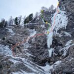
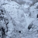
La cascata non si forma molto di frequente e nello stesso modo.
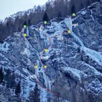
Avvicinamento
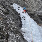
Da Pont Terrible seguire la carrozzabile estiva che porta a Brusà des Planes. Da qui continuare nel pianoro e una volta raggiunto il conoide di accesso a Coboldo Caustico proseguire ancora per 50 metri. Abbandonare la strada e salire sotto una parete strapiombante di roccia chiara e marcia, costeggiandola verso sinistra fino a raggiungere la linea (attenzione alle frange sopra la testa). 1,45 h
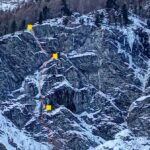
Descrizione
Superare il basamento della prima colonna di destra e salirla fino sotto lo strapiombo roccioso. Attraversare quindi a sx per 4 metri verso la nicchia e aggirare la seconda colonna dall’esterno (expo). Scalare anche questa e uscire su neve e cespugli per raggiungere il larice di sosta. Arrivati alla nicchia dietro la seconda colonna di può anche sbucare da dietro quest’ultima e raggiungere le piante (la salita risulta più facile).
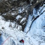
Discesa: in doppia dalla sosta (cordone su pianta da verificare). Scendendo non infilarsi nel buco dietro la colonna altrimenti si fatica molto a recuperare le corde.
La cascata è stata salita per la prima volta verso fine anni ‘80 inizio anni ‘90 insieme ad altre linee formate solo in quegli anni sul resto della parete e per decenni non è mai più stata presa in considerazione.
Nelle vicinanze Mappa
Itinerari
17/01/2024 TO, Sauze di Cesana 100 m II, 5, M6 Nord
Valle Argentera – Ambarass a serne (Cascate)
 150m
150m
17/01/2024 TO, Sauze di Cesana 100 m III, 5, M5 Nord
Valle Argentera – La chiave perduta (Cascata)
 150m
150m
21/02/2025 TO, Sauze di Cesana 110 m III, 4+ Nord
Valle Argentera – Coboldo Caustico (Cascata)
 200m
200m
23/01/2024 TO, Sauze di Cesana 100 m II, 4+, M6 Nord
Valle Argentera – Pand’ice e Fuga dalla Panda (Cascate)
 200m
200m
20/01/2024 TO, Sauze di Cesana 120 m III, 5+, M7 Nord
Valle Argentera – Ecofly (Cascata)
 250m
250m
21/12/2025 TO, Sauze di Cesana 110 m III, 3 Nord-Est
Valle Argentera – Rio Gentira (Cascata del)
 250m
250m
18/02/2024 TO, Sauze di Cesana 120 m III, 5 Nord-Est
Valle Argentera – Frali Ice (Cascata)
 300m
300m
06/02/2024 TO, Sauze di Cesana 140 m III, 3 Est
Valle Argentera – Candelino dell’Elefantasma (Cascata)
450m
09/01/2023 TO, Sauze di Cesana 110 m III, 3+ Nord-Est
Valle Argentera – Anni di Ghiaccio (Cascata)
500m
16/02/2020 TO, Sauze di Cesana 60 m III, 3, M1 Nord
Valle Argentera – Foulard di Glassa (Cascata)
600m


