8.1Km
8.1Km
Note
 0m
1.2Km
1.2Km
1.2Km
1.2Km
1.4Km
1.4Km
1.4Km
1.4Km
0m
1.2Km
1.2Km
1.2Km
1.2Km
1.4Km
1.4Km
1.4Km
1.4Km
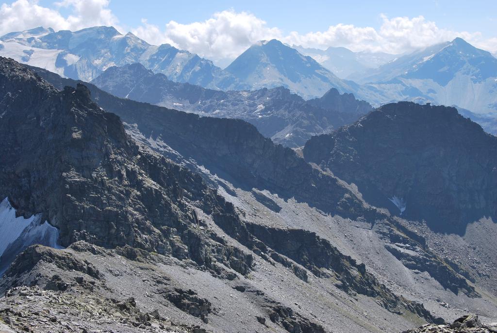
Il rifugio Deffeyes viene solitamente raggiunto da LaThuile lungo il classico percorso dell’Alta Via 2; la lunga escursione qui proposta permette invece di arrivare al rifugio lungo un percorso decisamente alternativo, attraverso i poco frequentati e quasi sconosciuti valloni di Ponteilles e Sozin, molto ben descritti da Luca Zavatta nella sua guida, e poi per un sentiero che si snoda sulle pendici del Gd Assaly, che collega il Rifugio con il Vallone di Bella Comba.
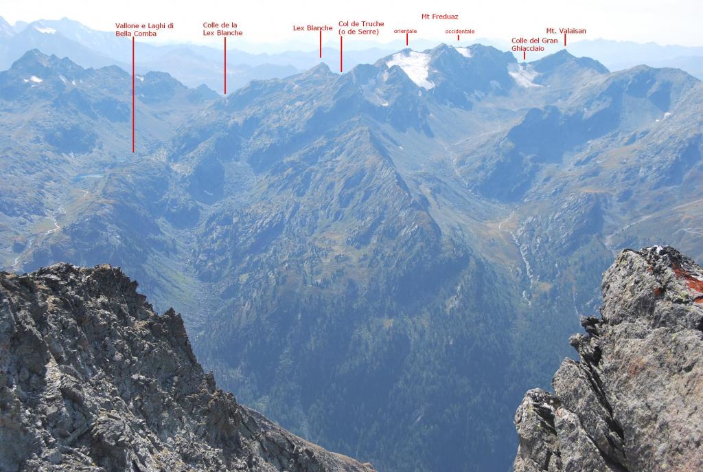
A questa escursione viene inoltre abbinata la salita alle panoramiche vette di Bella Valletta e del Mont Valaisan; anche in questo caso è stato scelto un percorso alternativo, via Arnouvaz – Cerellaz, per evitare la noiosa ed interminabile strada sterrata che sale da La Sapiniera ma soprattutto per evitare l’attraversamento del pianoro di Le Suche, ormai irrimediabilmente deturpato dalle polverose strade sterrate e da funi e tralicci degli impianti di risalita.
Invece, nessuna necessità di cercare percorsi alternativi per il sentiero che sale al Valaisan: infatti è impagabile il piacere di camminare sulla vecchia e stupenda mulattiera che, ancora lastricata in più punti, arriva fino ai ruderi dei ricoveri.
Avvicinamento
A questa escursione viene inoltre abbinata la salita alle panoramiche vette di Bella Valletta e del Mont Valaisan; anche in questo caso è stato scelto un percorso alternativo, via Arnouvaz – Cerellaz, per evitare la noiosa ed interminabile strada sterrata che sale da La Sapiniera ma soprattutto per evitare l’attraversamento del pianoro di Le Suche, ormai irrimediabilmente deturpato dalle polverose strade sterrate e da funi e tralicci degli impianti di risalita.
Invece, nessuna necessità di cercare percorsi alternativi per il sentiero che sale al Valaisan: infatti è impagabile il piacere di camminare sulla vecchia e stupenda mulattiera che, ancora lastricata in più punti, arriva fino ai ruderi dei ricoveri.
.
Descrizione
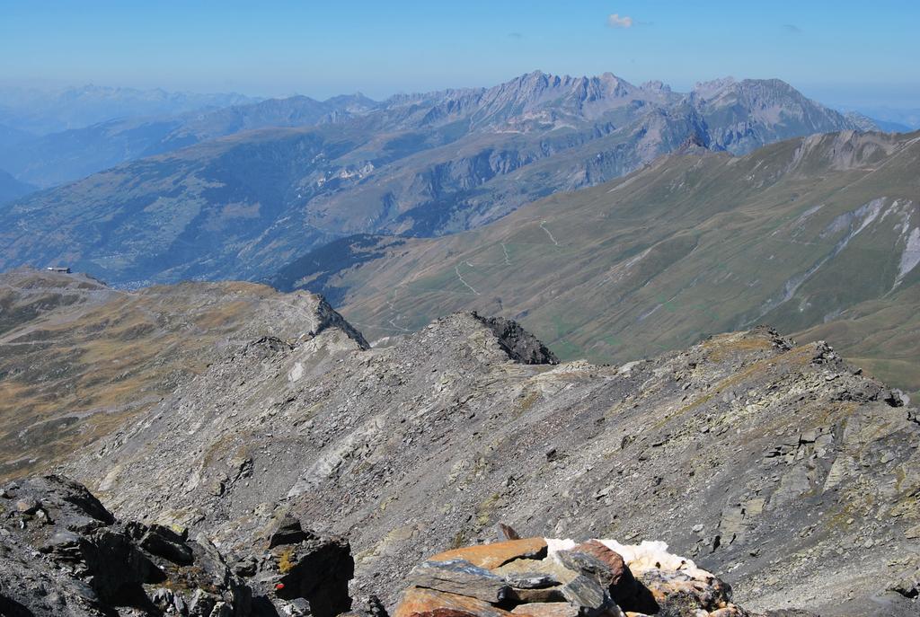
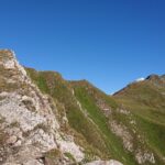
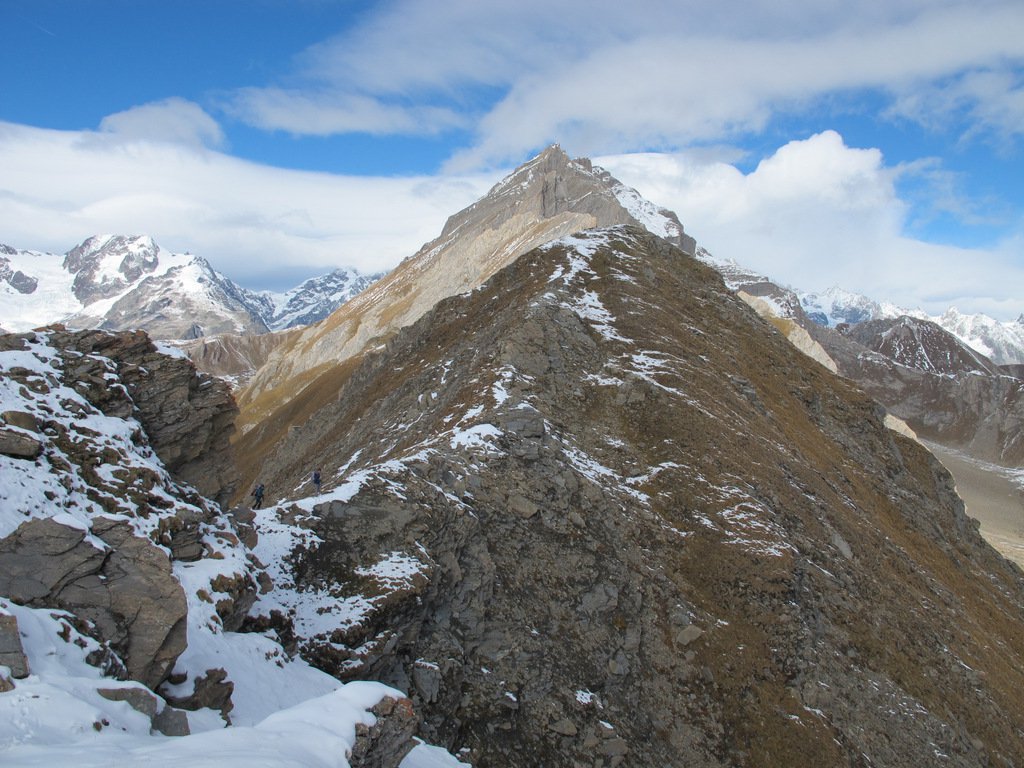
Da La Thuile (1442 m) raggiungere il Camping Rutor posto sulla sponda sinistra del torrente, costeggiarne la recinzione e raggiungere la pista che si trova poco sopra. Seguire in salita la pista fino ad una costruzione in cemento: qui la strada si restringe a sentiero ed entra nel bosco, dove sale dolcemente ed arriva ad incontrare una strada sterrata (d’inverno pista da sci). Seguire ora, in ripida salita, questa strada sterrata fino ad un curvone, dove si incrocia il torrente di Muret; qui si può scegliere se continuare lungo la strada oppure imboccare il sentiero che le corre parallelo (al curvone la traccia è ben visibile); con entrambi si arriva prima ai ruderi di La Posaz, poi si incontra un vecchio fabbricato oltre il quali si toccano gli alpeggi di Arnouvaz di sotto. Proseguendo sul sentiero sui prati, tagliando così tornanti della strada, si arriva all’alpeggio di Maison Grange, dal quale, ora di nuovo lungo la strada sterrata, si arriva agli alpeggi di Arnouvaz damon (1975) e, proseguendo oltre, a Cerellaz (2060 m). Ignorare ora tutte le strade sterrate e proseguire diritto (direzione W/SW) lungo un sentiero, abbastanza ben visibile tra i rododendri e che corre sul ciglio, fino ad incontrare il torrente che precipita nel Vallone di Ponteilles; costeggiarlo in salita, si incontrerà poi una traccia di bestiame che, seguita, si innesta sul sentiero n. 9D per il Mt. Valaisan proveniente da Le Suches. Questo sentiero, ora bellissima mulattiera lastricata e con muri a secco laterali, aggira prima un costone, quindi sale arrivando sulla panoramica cresta di confine e, con un lungo traverso, tocca la vetta di Bella Valletta (2811 m); dalla vetta si abbassa al sottostante colle (2743 m) dal quale risale fino alla vetta del Mt. Valaisan (2891 m).
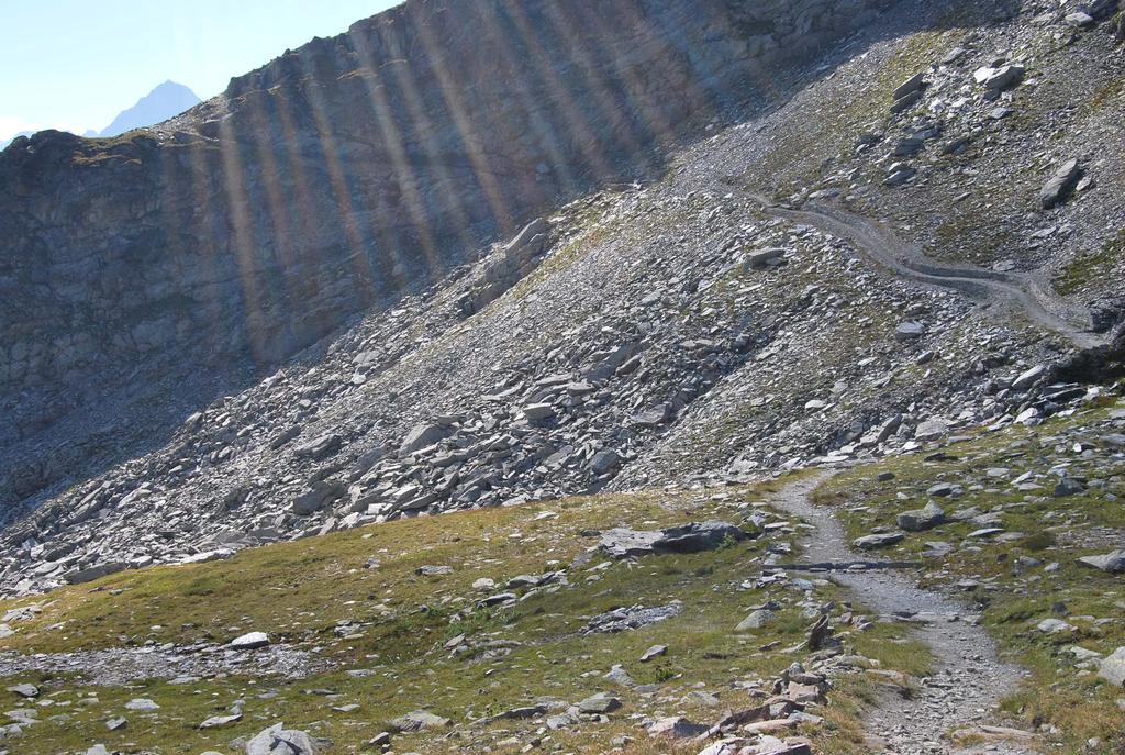
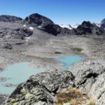
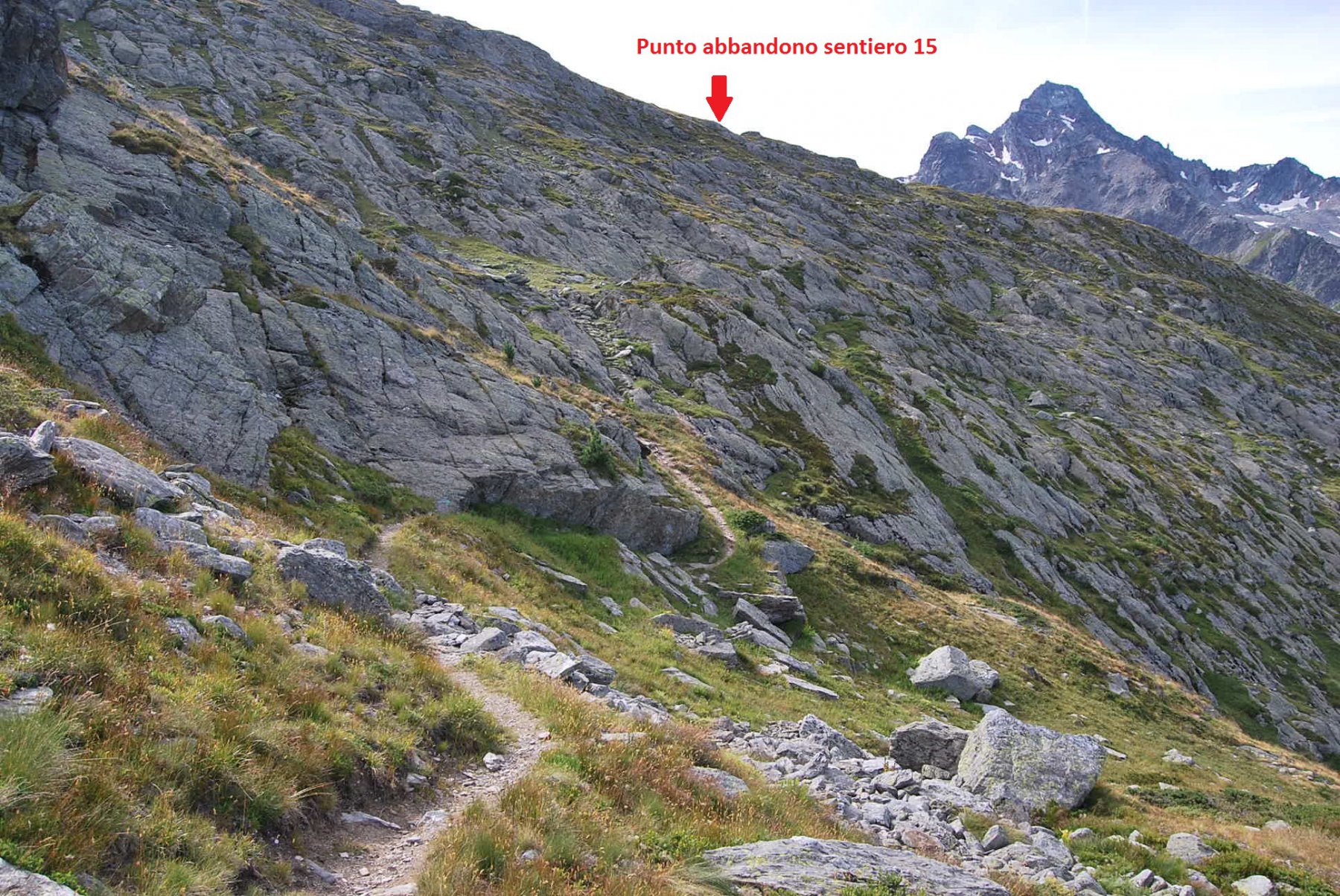
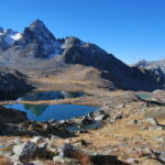
In discesa si segue lo stesso percorso dell’andata fino al torrente, dove occorre prestare attenzione per individuare degli ometti che segnalano il sentiero che, staccandosi sulla destra, scende nel Vallone di Ponteilles. Seguire questo sentiero non è molto agevole perchè gli ometti presto terminano e la traccia non è sempre evidente; comunque, per percorso a volte intuitivo si arriva ai ruderi degli alpeggi di Ponteilles (2060 m), dove si ritrova, stavolta molto ben marcato, il sentiero proveniente da Cerellaz (segnavia n. 18) che attraversa il torrente su un ponte in legno, risale sull’altro versante del vallone, aggira la cresta in prossimità del Monte Thuillette ed entra nella Comba Sozin. Si attraversa con un giro a semicerchio la Comba Sozin, costeggiandone il piccolo Lago, e si risale sul bordo del vallone fino ad incontrare il sentiero n. 8 proveniente da La Joux e che entra nel vallone di Bella Comba. Seguirlo fino ad incontrare sulla destra i ruderi di un fabbricato in prossimità dei quali si stacca, sulla sponda opposta del torrente, il sentiero che, individuato da ometti, sale sulla pietraia ed arriva ad incrociare il torrente Rutor. Attraversare il torrente sul ponte in legno e dirigersi verso l’emissario del Lago Inferiore, costeggiarlo fino ad arrivare in vista della Cappella di S. Margherita, che si raggiunge superando una facile placca rocciosa. Dalla Cappella si prosegue fino al Rifugio Deffeyes (2500 m), dal quale si scende poi a La Joux (1646 m) lungo il sentiero n. 3-8-Alta Via 2, infine a LaThuile.
Difficoltà: EE per la difficoltà di individuare e ritrovare alcuni tratti di sentiero, e per la lunghezza del percorso. Consigliata una conoscenza preliminare della zona ed un buon allenamento.
Dislivello positivo totale: 1889 m, somma dei 1449 m da LaThuile al Valaisan e dei 440 m dai ruderi di Ponteilles al Rifugio Deffeyes.
- Cartografia:
- Carte L’Escursionista, Fg. 2 (La Thuile), Scala 1:25000.
- Bibliografia:
- L. Zavatta – Le Valli del M. Bianco – L’Escursionista Editore
Nelle vicinanze Mappa
Itinerari
28/09/2025 AO, La Thuile D+ 1100 m E Nord-Est
Chaz Duraz (Mont) da La Thuile
 0m
0m
09/08/2024 AO, La Thuile D+ 541 m E Varie
Plan Praz e Fort Saint Maurice da Bouic
 1.2Km
1.2Km
28/07/2010 AO, La Thuile D+ 950 m E Ovest
Croce (Punta e Colle della) da Bouic
 1.2Km
1.2Km
31/07/2022 AO, La Thuile D+ 1417 m EE Varie
Alto (Passo) da La Thuile, traversata a La Salle per i Laghi di Usselettes
 1.2Km
1.2Km
19/07/2020 AO, La Thuile D+ 1709 m EE Varie
Colmet (Mont) da La Thuile, traversata a La Salle per la cresta SO
 1.2Km
1.2Km
23/10/2021 AO, La Thuile D+ 1142 m EE Varie
Deffeyes Albert (Rifugio) e laghi del Rutor da La Thuile, anello per Plan de la Lière e Comba Sorda
 1.4Km
1.4Km
10/09/2023 AO, La Thuile D+ 1265 m EE Varie
Belleface (Mont, Punta Sud) da La Thuile
 1.4Km
1.4Km
17/10/2015 AO, La Thuile D+ 1347 m EE Varie
Combe Varin (Monte) da La Thuile
 1.4Km
1.4Km
04/08/2011 AO, La Thuile D+ 1393 m EE Varie
Freduaz Orientale (Monte) da La Thuile, traversata al Colle del Piccolo San Bernardo per il Col de la Lex Blanche
 1.4Km
1.4Km
26/06/2005 AO, La Thuile D+ 1290 m E Tutte
Fortin (Mont) da La Thuile, traversata a la Visaille
1.4Km