 5.6Km
5.6Km
Note
 4.3Km
8.6Km
8.7Km
8.8Km
8.8Km
9Km
9Km
9Km
9Km
4.3Km
8.6Km
8.7Km
8.8Km
8.8Km
9Km
9Km
9Km
9Km
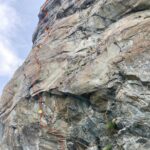
Simpatica via di arrampicata su buona roccia, si delinea tra splendidi diedri e lisce placche culminado sul primo gendarme posto tra il colle Valmeriana e il Mont Ruvic.
Offre un panorama meraviglioso dopo una suggestiva avventura nella selvaggia Valmeriana.
Avvicinamento
Offre un panorama meraviglioso dopo una suggestiva avventura nella selvaggia Valmeriana.
Dal casello autostradale di Chatillon raggiungere Pontey, superare l'abitato di Prelaz e continuare in direzione Chambave, prendere il bivio a sinistra salendo verso Verthuy e successivamente Cloutra dove termina la strada asfaltata.
Seguire la pista poderale o il sentiero fino all'alpeggio Valmeriana, da qui seguire il sentiero verso il col Giron, superare il Pian Lavué e il bivio per il colle Valmeriana.
Continuare diagonalmente sino ai resti di un'antica costruzione, attraversare il pianoro disseminato di enormi blocchi e abbandonare il sentiero volgendo verso sud-est.
Risalire la pietraia alla base della bastionata rocciosa aggirandola leggermente a sinistra. un omino di pietra segnala il punto di attacco della via.
Descrizione
Seguire la pista poderale o il sentiero fino all'alpeggio Valmeriana, da qui seguire il sentiero verso il col Giron, superare il Pian Lavué e il bivio per il colle Valmeriana.
Continuare diagonalmente sino ai resti di un'antica costruzione, attraversare il pianoro disseminato di enormi blocchi e abbandonare il sentiero volgendo verso sud-est.
Risalire la pietraia alla base della bastionata rocciosa aggirandola leggermente a sinistra. un omino di pietra segnala il punto di attacco della via.
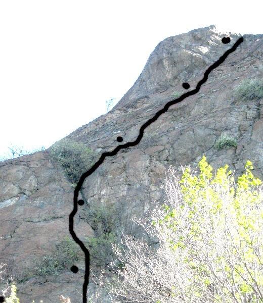
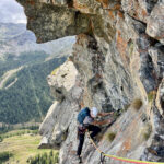
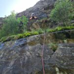
L1 – Salire l’evidente diedro prima a sinistra e poi spostarsi a quello di destra, risalire sino alla comoda cengia (sosta su clessidra) 5+ 1 chiodo
L2 – Proseguire nel diedro superare il tetto sfruttando la fessura (6a) e uscire dove questa si abbatte (sosta su 2 chiodi).
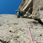
L3 – Continuare sulla sinistra seguendo la cengia diedro per 20 m. (3° – 4°) sostare sulla cengia sotto il muro verticale (sosta su clessidra)
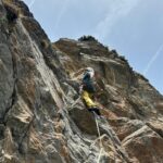
L4 – Salire il muto verticale (5°) 1 chiodo, ribaltarsi sulla placca sovrastante. Proseguire in verticale (rocce verdi un pò rotte) uscendo sulla grande placconata nord, risalire quest’ultima per qualche metro e sostare su una grossa lama.
L5 – Continuare lungo la facile placconata seguendo il suo margine sinistro sino al bordo superiore (2°).
L6 – Portarsi a sinistra dove un facile camino permette di superare il risalto (3°) e poi seguire l’affilata crestina.
L7 – Risalire la placca che volge a sinistra giungendo in cima (3°)
Itinerario di discesa
Si sconsiglia la discesa in doppia sulla via,
Scendere verso nord-est per delle facili balze, aggirare sulla destra un gendarme e giungere al colle Valmeriana, dove il comodo sentiero ricongiunge all’alpeggio omonimo.
Nelle vicinanze Mappa
Itinerari
20/07/2022 AO, Pontey 5c, 5a obbl. Nord
Pontey (Sperone di)
 4.3Km
4.3Km
01/06/2025 AO, 7a, 6b+ obbl. Nord-Est
Pilier Rhodo – Wonder Crack
 8.6Km
8.6Km
10/10/2024 AO, Montjovet 6a, 5a obbl. Sud
Montjovet (Gola di) – Via di Capaferita
 8.7Km
8.7Km
27/07/2025 AO, Champorcher 4, 3 obbl. Sud-Ovest
Raty (Bec) – Via delle Placche VIA CHIUSA
 8.8Km
8.8Km
23/06/2021 AO, Champorcher 5a, 4 obbl. Sud
Raty (Bec), Parete Sud – Sperone Centrale
 8.8Km
8.8Km
08/09/2025 AO, Champorcher 5a, 5a obbl. Sud
Raty (Bec) – Sperone di sinistra
8.8Km
24/06/2026 AO, Champorcher 6a+, 5c obbl. Sud-Est
Raty (Bec) – Ex Articolo 18
 9Km
9Km
30/05/2026 AO, Champorcher 6b, 6b obbl. Sud-Est
Raty (Bec) – Aspettando Danilo
 9Km
9Km
29/10/2024 AO, Montjovet 6a, 5c obbl. Est
Montjovet (Gola di) – Vecchio Cuore Granata
 9Km
9Km
24/08/2024 AO, Champorcher 5c, 5c obbl. Sud
Raty (Bec) – Via dei Diedri
 9Km
9Km