 1.4Km
1.4Km


Note
Storico
 1.5Km
2.4Km
2.9Km
3.1Km
3.9Km
3.9Km
4.1Km
4.5Km
1.5Km
2.4Km
2.9Km
3.1Km
3.9Km
3.9Km
4.1Km
4.5Km
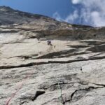
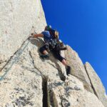
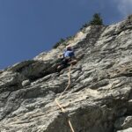
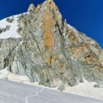
Arrampicata su ottima roccia granitica che si svolge nell’ambiente sempre magico del Monte Bianco italiano, ripido e severo anche se… a due passi dalla Skyway!
Equipaggiamento : normale da arrampicata, friend piccoli, i tiri non superano i 30 metri.
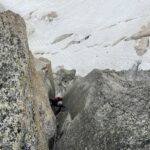
Avvicinamento
Equipaggiamento : normale da arrampicata, friend piccoli, i tiri non superano i 30 metri.
A Courmayeur (AO), località Entrèves, prendere la funivia Skyway fino alla stazione intermedia del Pavillon 2177 m. Da lì seguire sentiero per il Rifugio Torino. Al primo tornante andare a destra e seguire i tubi dell’acqua del giardino botanico. Continuare fino alle vasche dell’acqua, attraversare il torrente e proseguire, sempre verso destra, per ripide coste moreniche erbose (tracce di sentiero). Attraversare un altro torrente ancora a destra e continuare fino ai piedi dell’evidente sperone di roccia chiara lungo il quale attacca la via. Ometto e scritta alla partenza, quota 2530 m. 1 h dal Pavillon.
Descrizione
- L1: placca verso destra, fix visibile, 5b, sosta da calata 30 m;
- L2: traversare in diagonale verso destra per 15 m, poi dritti su piccolo sperone. 5c, sosta da calata 30 m;
- L3: verticalmente sopra la sosta, 5a, traverso a sinistra (blocchi), muro con due fessure parallele 6a, a sinistra piccolo strapiombo 6a+. Sosta da calata, 30 m;
- L4: diritti per roccia facile con erba, 4a, sosta da calata, 30 m;
- L5: entrare in un evidente canale, 2 fix, e risalirlo fino a una grande cengia. Sosta da calata, 30 m;
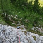
Trasferimento: dalla grande cengia seguire le tracce verso destra (ometto) e aggirare uno sperone roccioso verso sinistra che porta sul bordo sinistro della torre lungo la quale corre la seconda parte della via. 10’ di marcia. Partenza di L6 evidente con fix e cordone giallo.
- L6: diritti su mix erba/roccia, III, sosta da calata 30 m;
- L7: diritti per placche appoggiate, 4a, sosta da calata 30 m;
- L8: placca e passaggio su pilastrino verticale, 5b, sosta da calata, 30 m;
- L9: dritti per evidente diedro tecnico da scalare a sinistra, 6a+, sosta da calata, 30 m;
- L10: traversare a sinistra per 4 m. Salire dritti a una cengia, 5b, affrontare un muro nero con fessure oblique sulla destra, 5c, sosta da calata, 30 m;
- L11: sperone roccioso sotto la punta sommitale, 15 m, 5b, tratto finale in diedro verticale atletico, 6a+, sosta di calata, 30 m (cima della torre);
- L12: (facoltativo) diritti su cresta e placca, 4a, sosta di calata, 20 m.
Discesa: calate da 30 m lungo la via di salita.
Massimo Datrino e Gianluca Marra (2 e 20 settembre 2022) dal basso e attrezzata con fix inox,
- Bibliografia:
-
www.up-climbing.com/multipitch/news-multipitch/tower-in-the-sky-6a-350-m/
https://www.vielunghevalledaosta.com/
Nelle vicinanze Mappa
Itinerari
27/12/2022 AO, Courmayeur 6a+, 5a obbl., a0 Nord-Ovest
Marbrées (Aiguilles) – Trabaldo
1.3Km
06/08/2022 AO, Courmayeur 7c+, 6c obbl. Est
Brenva (Aiguille de la) – Mares
 1.5Km
1.5Km
19/07/2026 Haute-Savoie, Chamonix-Mont-Blanc 5a, 4 obbl. Nord
Petit Flambeau – Via Laurent Grivel
 2.4Km
2.4Km
13/08/2025 AO, Chamonix-Mont-Blanc 7a, 6b+ obbl., a0 Nord-Est
Vierge (la) – La Tète du Dragon
 2.9Km
2.9Km
04/07/2026 AO, Courmayeur 6a, 5c obbl. Est
Brenva (Aiguille de la), Père Eternel – Via Papa Giovanni Paolo II + Ottoz/Grivel
 3.1Km
3.1Km
11/08/2022 AO, Courmayeur 6c, 6a+ obbl. Est
Chetif (Mont) – Punta Rovente
 3.9Km
3.9Km
20/08/2023 AO, Courmayeur 6a+, 6a obbl. Nord-Est
Chetif (Mont) – Madonna dell’Est o Madonnina
 3.9Km
3.9Km
17/07/2024 Haute-Savoie, Chamonix-Mont-Blanc 6b+, 6a+ obbl. Nord-Est
Tour Ronde – Via Cheraz
 4.1Km
4.1Km
02/07/2026 AO, Courmayeur 5c, 5a obbl. Nord-Ovest
Chetif (Mont) – 27 Luglio
 4.5Km
4.5Km
04/01/2023 AO, Courmayeur 7a+, 6c obbl. Sud-Ovest
Saxe (Mont de la) – Non Toccatemi il Pilastro
4.6Km

