800m
800m
Note
 100m
150m
200m
250m
450m
500m
500m
550m
100m
150m
200m
250m
450m
500m
500m
550m
800m
5.1Km
7.1Km
7.3Km
7.3Km
7.5Km
7.5Km
7.7Km
7.7Km
7.7Km
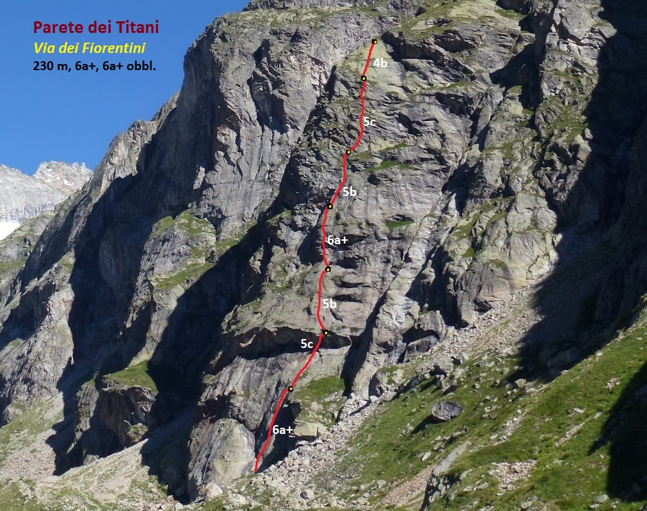
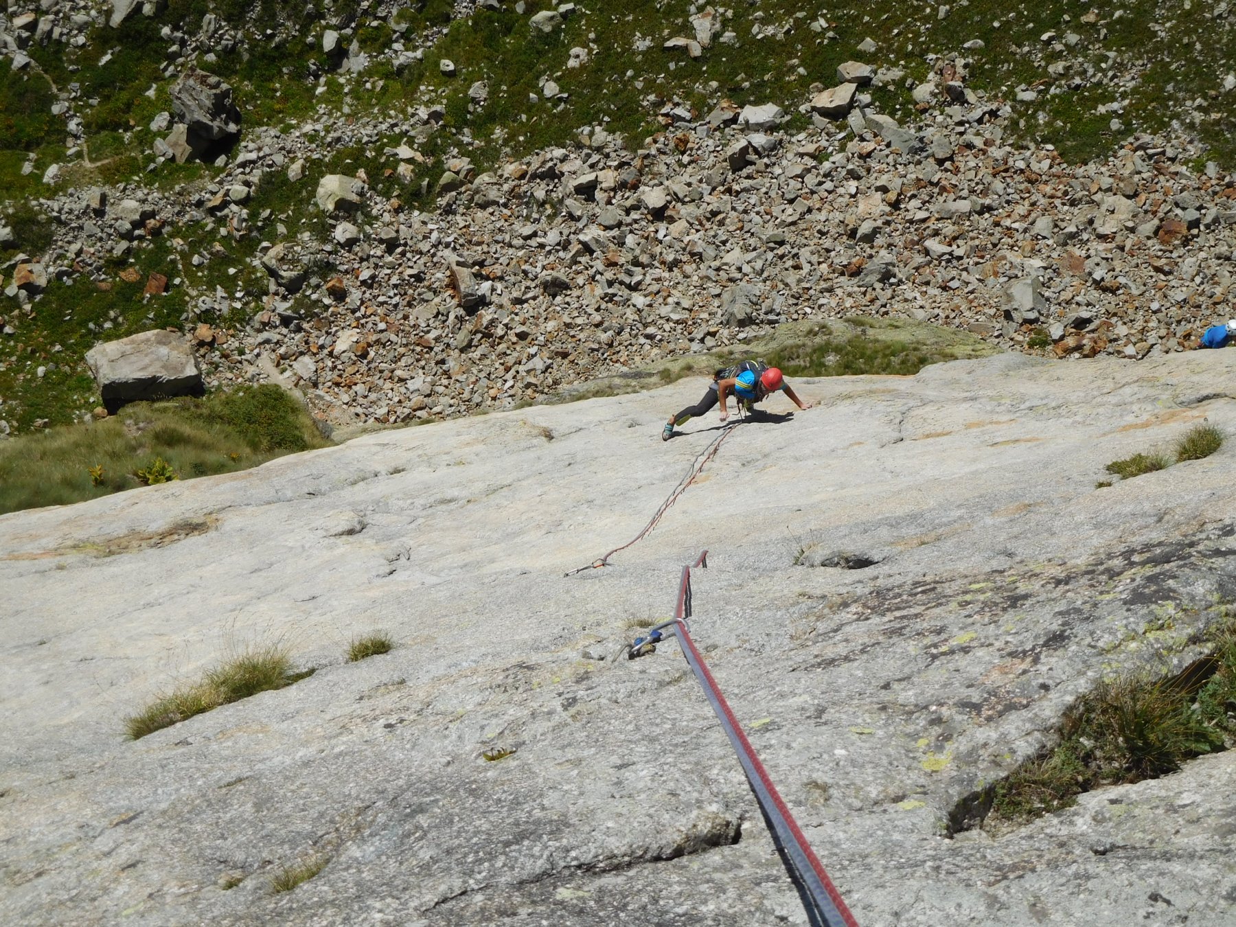
Via di placca su roccia molto bella che corre parallelamente alle vicine Genepy e Genepy 2.
Su tutta la via ci sono soltanto due passi difficili, il primo su placca, nel primo tiro, obbligatorio, il secondo su muretto leggermente strapiombante al quarto tiro, scorbutico. Il resto della via è costante sul 5b-5c, con chiodatura distanziata che richiede sicurezza sul grado. Spit nuovi e vecchi (ma ancora buoni) si alternano. Soste quasi sempre comode.
Materiale: 10 rinvii, corde da 60 m, casco. Protezioni veloci non molto utili, dove è chiodato lungo non si mette granché.
Avvicinamento
Su tutta la via ci sono soltanto due passi difficili, il primo su placca, nel primo tiro, obbligatorio, il secondo su muretto leggermente strapiombante al quarto tiro, scorbutico. Il resto della via è costante sul 5b-5c, con chiodatura distanziata che richiede sicurezza sul grado. Spit nuovi e vecchi (ma ancora buoni) si alternano. Soste quasi sempre comode.
Materiale: 10 rinvii, corde da 60 m, casco. Protezioni veloci non molto utili, dove è chiodato lungo non si mette granché.
Da Arnouva seguire il sentiero per il rifugio Dalmazzi, fin nei pressi dell'evidente parete, tagliata da un marcato tetto a 70 m da terra circa.
L'attacco è posto sulla destra della grande placca basale, al di sotto del giardino pensile, una trentina di metri più in basso rispetto all'attacco di "Genepy". 40'.
Descrizione
L'attacco è posto sulla destra della grande placca basale, al di sotto del giardino pensile, una trentina di metri più in basso rispetto all'attacco di "Genepy". 40'.
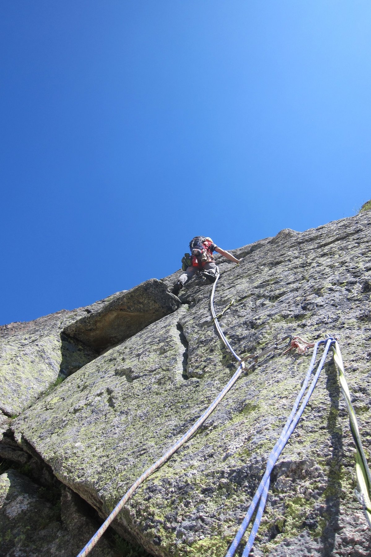
- L1: placca con alcuni passi delicati, uno su tutti, 6a+ solido e obbligatorio. Chiodatura a tratti distanziata.
- L2: placca, diedrino leggermente strapiombante non difficile, uscita su erba ollina. 5c.
- L3: placca facile con un solo passo un po’ delicato. 5b.
- L4: spigolo arrotondato facile, muretto/diedrino difficile con spit ravvicinati, poi placca non difficile. 6a+.
- L5: placche facili e terreno erboso. 5b
- L6: placche e muretti con passi interessanti. 5c
- L7: placche abbattute lisce ma facili. 4b.
Discesa: doppie lungo la via, l’ultima alla base evitabile scendendo a destra sul giardino pensile fino alla base di “Genepy”.
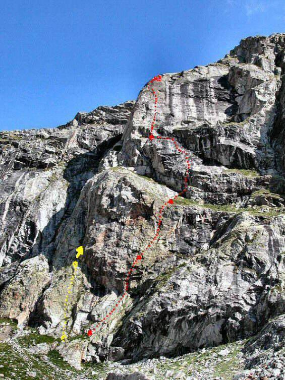
Nelle vicinanze Mappa
Itinerari
20/08/2024 AO, Courmayeur 6a, 5c obbl. Sud
Val Ferret, Parete dei Titani – Génépy 1
 100m
100m
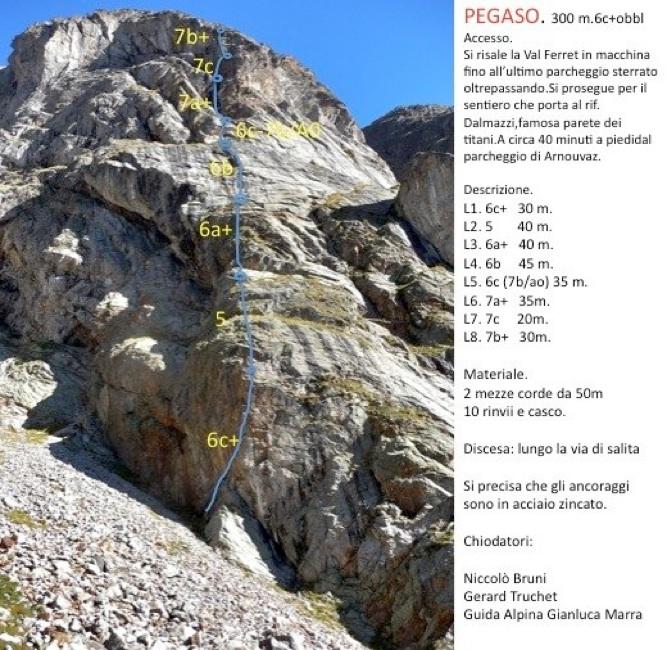
13/02/2023 AO, Courmayeur 7c, 6c+ obbl. Sud-Ovest
Val Ferret, Parete dei Titani – Pegaso
 150m
150m
21/06/2020 AO, Courmayeur 7a, 6b+ obbl. Sud-Ovest
Val Ferret, Parete dei Titani – Ahi Ahi Ahi
 200m
200m
04/09/2019 AO, Courmayeur 6c, 6b obbl. Sud
Val Ferret, Parete dei Titani – Titanic
 250m
250m
08/10/2016 AO, Courmayeur 6c, 6b obbl. Sud-Ovest
Val Ferret, Parete dei Titani – 13 Ans de Reflexion
300m
11/07/2024 AO, Courmayeur 6c, 6a+ obbl. Sud-Ovest
Val Ferret, Parete dei Titani – Garage
400m
09/07/2011 AO, Courmayeur 6b, 6a obbl. Sud
Triolet (Monts Rouges de), Contrafforti del Rifugio Dalmazzi – Quelli che la Montagna
 450m
450m
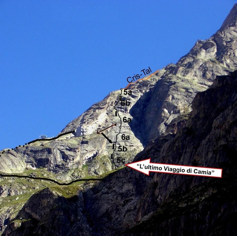
21/08/2024 AO, Courmayeur 6a, 5b obbl. Sud
Triolet (Monts Rouges de), Punta Est – Cris-Tal
 500m
500m
20/08/2024 AO, Courmayeur 6b, 5c obbl. Sud
Triolet (Monts Rouges de), Punta Est – L’Ultimo Viaggio di Camia
 500m
500m
09/09/2014 AO, Courmayeur 6b+, 6a+ obbl. Sud
Triolet (Monts Rouges de), Punta Est, Cresta Sud – La Ragazza di Ipanema
 550m
550m
Servizi
800m
5.1Km
Lavachey Albergo
Courmayeur
7.1Km
Cabane de l’A Neuve Rifugio
La Fouly 7.3Km
7.3Km
Chalet le Dolent B&B
La Fouly 7.3Km
7.3Km
Hôtel du Col de Fenêtre Albergo
La Fouly 7.5Km
7.5Km
Majya-Joie Ristorante
La Fouly 7.5Km
7.5Km
Auberge de Maya Joie Albergo
La Fouly 7.7Km
7.7Km
Zanskar Sport Servizi
La Fouly 7.7Km
7.7Km
Auberge des Glaciers Albergo
La Fouly 7.7Km
7.7Km