 6.2Km
6.2Km
Note
Storico
 0m
0m
50m
50m
50m
50m
50m
50m
50m
50m
0m
0m
50m
50m
50m
50m
50m
50m
50m
50m
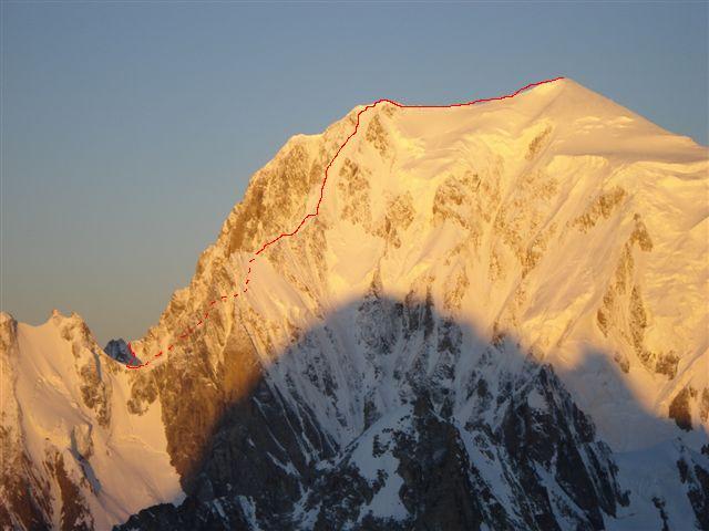
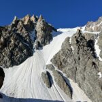
La prima e più evidente linea di questo eccezionale versante, presenta una serie di tiri di grande bellezza, esposti al sole e posti in uno degli angoli più belli di tutto il massiccio del Monte Bianco.
Le lunghezze chiave sono la prima, una vera lunghezza fantasma formata abbastanza raramente e l’ultima, più consistente e meno effimera ma più continua e atletica.
Avvicinamento
Le lunghezze chiave sono la prima, una vera lunghezza fantasma formata abbastanza raramente e l’ultima, più consistente e meno effimera ma più continua e atletica.
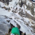
Prendere piede sul ghiacciaio del Brouillard per mezzo di una breve doppia qualche metro a monte del bivacco Grassi/Lampugnani, con sosta su cordone e maillon in loco.
In circa 20 minuti, si è alla base del primo tiro per mezzo di facile pendio nevoso ascendente a sinistra.
Descrizione
In circa 20 minuti, si è alla base del primo tiro per mezzo di facile pendio nevoso ascendente a sinistra.
La via conta sei lunghezze da 50 metri, compresi i brevi tratti nevosi.
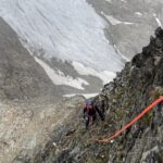
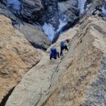
- L1- 50 metri – grado 4: seguire lo stretto nastro ghiacciato, sostenuto per i primi 20 metri con un breve tratto strapiombante, per uscire a sinistra su terreno più appoggiato.Sosta a destra su camme
- L2 – breve canale nevoso e poi diritti per una bellissima goulotte di circa 20 metri, difficoltà grado 3, sosta a sinistra su camme o su viti.
- L3 – 50 metri – grado 3 goulotte di stampo classico e canale nevoso. Sosta a sinistra su camme.
- L4, L5 – 50 metri – grado 4 : i tiri possono essere uniti e in questo caso si sfalsa il breve tratto di nevaio. Muro verticale a sinistra di circa 8 metri e continuità su ghiaccio ripido ma più appoggiato sino all’uscita.Oppure, nel caso in cui si intenda spezzare la lunghezza, sosta su viti a destra, sotto l’ultima impennata.
- L6 – 40 metri – crux grado 4+ . Dalla sosta su camme a destra, qualche metro di ingresso e poi 12 metri verticali su ghiaccio compatto e atletico, poi sempre sostenuto e 85 gradi in uscita.Sosta in uscita su viti.
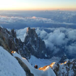
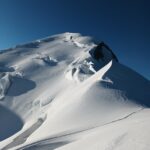
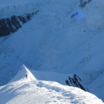
Da questo punto è possibile calarsi in doppia su clessidre oppure proseguire per circa 300 metri di canale nevoso con qualche breve risalto di ghiaccio più ripido per prendere piede sulla cresta del Brouillard per mezzo di due lunghezze di misto classico, arrivando a quota 4400 circa, a monte del picco Luigi Amedeo. Da quel punto, in vetta al Monte Bianco, con tempi e difficoltà a seconda delle condizioni
Fantastico itinerario aperto nel 1982, opera di P.Gabarrou e P.A Steiner.
Una linea visionaria.
Una linea visionaria.
- Cartografia:
- IGC Monte Bianco
- Bibliografia:
-
Guida dei Monti d’Italia, G.Buscaini, Monte Bianco volume 1
Neige, Glace et Mixte, F.Damilano
Nelle vicinanze Mappa
Itinerari
21/08/2013 AO, Courmayeur D+ 3200 m D+ Sud-Est
Bianco (Monte) Cresta di Peuterey dal Col Eccles
 0m
0m
24/08/2025 AO, Courmayeur D+ 1400 m PD- Sud
Estellette (Aiguille d’) da La Visaille
 0m
0m
29/08/2021 AO, Courmayeur D+ 3237 m D+ Sud
Bianco (Monte) Cresta dell’Innominata
 50m
50m
21/06/2026 AO, Courmayeur D+ 3110 m AD- Varie
Bianco (Monte) Via Normale Italiana o Via Ratti dal Rifugio Gonella
 50m
50m
26/07/1998 AO, Courmayeur D+ 1457 m F Varie
Lechaud (Punta) da La Visaille per il Colle di Chavannes ed il versante Est
 50m
50m
14/06/2026 AO, Courmayeur D+ 2200 m AD- Varie
Trelatete (Aiguille de) traversata dal Bivacco Rainetto al Rifugio Elisabetta
 50m
50m
09/08/2024 AO, Courmayeur D+ 3400 m ED- Sud-Est
Bianco (Monte) Pilone Centrale Freney – Via classica
 50m
50m
02/07/2021 AO, Courmayeur D+ 400 m TD+ Sud-Est
Brouillard (Pilastro Rosso del) – Via Bonatti-Oggioni
 50m
50m
12/08/2021 AO, Courmayeur D+ 2600 m AD Est
Bionnassay (Aiguille de) Cresta Est
 50m
50m
14/07/2024 AO, Courmayeur D+ 3200 m D- Sud-Ovest
Bianco (Monte) Sperone della Tournette
 50m
50m