Note
 7.9Km
12.3Km
15Km
21.8Km
22.3Km
23Km
23Km
24Km
7.9Km
12.3Km
15Km
21.8Km
22.3Km
23Km
23Km
24Km
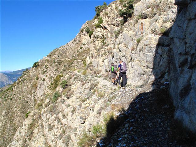
Per arrivere a Revest les Roches il sentiero è in parte abbandonato e quindi un pò invaso da vegetazione. Dopo il paese è bello.
Avvicinamento
Come si arriva: da Nizza si sale lungo il Var e dopo Plan du Var (bivio) si prosegue x Isola Km 2,6 e si parcheggia in uno slargo.
Descrizione
Si scende a prendere la passerella, sospesa con funi d’acciaio, che attraversa il Var, poi a Sx in direz. S., si attraversa poi il canale, quindi nuovamente a Sx per inoltrarsi nel selvaggio Vallone des Hirondelles (sentiero evidente e un pò invaso)Al bivio (palina e grosse quercie) tralasciare la diramazione a Sx e proseguire diritti. A q. 380 c. (casetta) proseguire un pò su sterrato e prendere a Dx il vecchio sentiero, un pò invaso, che porta a Revest lles Roches q.852 (sin quì si può arrivare in auto). Appena usciti dal paese in direz. O-NO si svolta a Dx e su sentiero ben segnalato e panoramico, che contorna, con qualche piccolo saliscendi, quasi tutta la montagna, si giunge in vetta. Discesa per lo stesso itinerario.
- Cartografia:
- IGN 3641 OT al 25.000
Nelle vicinanze Mappa
Itinerari
18/10/2009 Alpes-Maritimes, Utelle D+ 800 m E Sud-Ovest
Utelle (Brec d’) da Utelle
 7.9Km
7.9Km
05/12/2009 Alpes-Maritimes, Lantosque D+ 1190 m E Sud-Est
Bellegarde (Cime de) da le Suquet, GR510
 12.3Km
04/01/2025 Alpes-Maritimes, Saint-Jeannet D+ 500 m E Tutte
Saint Jeannet (Baou de) dal Saint Jeannet, anello
 15Km
15Km
30/12/2019 Alpes-Maritimes, Villefranche-sur-Mer D+ 340 m T Varie
Alban (Mont) e Mont Boron da Villefranche sur Mer
 21.8Km
03/01/2016 Alpes-Maritimes, Tourrettes-sur-Loup D+ 700 m E Varie
Puy de Naouri da Tourrettes sur Loup, anello
 22.3Km
06/04/2014 Alpes-Maritimes, Nice D+ 200 m T Tutte
Boron (Mont) da Nizza, anello
22.6Km
23/04/2023 Alpes-Maritimes, Beaulieu-sur-Mer D+ 305 m E Varie
Saint-Hospice (Pointe de) Tour du Cap Ferrat
 23Km
23Km
02/10/2014 Alpes-Maritimes, Valdeblore D+ 1400 m EE Tutte
Pepoiri (Mont) da La Colmiane per Cime Belletze Vallone Anduebis
 23Km
23Km
21/04/2025 Alpes-Maritimes, Èze D+ 700 m T Sud
Revere (Fort de la) e la Simboula da Eze Bord de la Mere
 24Km
24Km
13/07/2019 Alpes-Maritimes, Moulinet D+ 600 m T Tutte
Scoubayoun (Tete de) e Tete de la Scalette dal Col de Turini, anello
24.8Km