1.2Km
1.2Km

Note
 50m
50m
50m
50m
50m
1.4Km
1.4Km
1.5Km
1.5Km
1.5Km
50m
50m
50m
50m
50m
1.4Km
1.4Km
1.5Km
1.5Km
1.5Km
1.2Km
 1.2Km
1.2Km
1.2Km
1.3Km
1.4Km
1.4Km
1.5Km
1.6Km
1.6Km
1.7Km
Cime secondarie del Vallon de Menouve, "nascoste" rispetto alla più nota Pointe de Barasson. Gli ultimi 450 m di salita si svolgono in assenza di sentiero e tracce, ma su terreno non problematico (zone di pietraia parzialmente evitabili).
Avvicinamento
Da Aosta imboccare la strada per il Colle del Gran San Bernardo. Raggiungere il centro di Etroubles e poco oltre il tornante a centro paese, ma prima di arrivare a Saint Oyen, svoltare a dx in salita (cartello per diverse frazioni e Bivacco Molline). Seguire la strada per la frazione Eternod. Oltrepassare la stradina che scende verso il centro del borgo e proseguire lungo la sterrata in buone condizioni per circa 1 km fino ad un tornante con un ampio spiazzo dove si posteggia, prima dei divieti.
Descrizione
Partenza da Eternod (consigliato):
dal tornante si percorre la strada sterrata sulla destra, pressochè pianeggiante, che dopo una curva si immette dall’alto nel Vallon de Menouve (si intravedono sotto le case di Prailles). Attraversato un pascolo si entra nel bosco incontrando il tracciato del Ru Neuf d’Eternon, nel fresco bosco, che condurrà ai pascoli dell’Alpe Comba German 1812 m.
Partenza da Prailles (più lungo):
Dal parcheggio poco a monte di Prailles Dessous 1566 m) imboccare la strada sterrata che si inoltra nel Vallon de Menouve seguendola, per poco meno di un chilometro, fin dove si incontra un sentiero che scende verso destra (indicazioni poco prima sulla sinistra per l’Alta Via n. 1 e i sentieri 20 e 20B e freccia gialla su pietra all’imbocco del sentiero), attraversa un ponte sul Torrent de Menouve, poi inizia a salire nel bosco di conifere che ricopre il versante orientale del vallone. Raggiunto un ripiano poco sotto l’Alpe Comba German, si abbandona la pista del vallone per raggiungere il sovrastante alpeggio, e da qui collegarsi al percorso proveniente da Eternon.
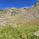
Da Comba German si trascura la strada che scende verso il fondo del vallone, puntando ad un antico alpeggio posto sul dosso erboso poco distante, ai limiti del bosco di larici in cui ci si addentrerà. Dopo alcuni tornanti ed un lungo traverso, il bosco termina in prossimità dell’Alpe Tracaoudette 2132 m. Ora gioco-forza andrà seguita la pista poderale per un lungo tratto, che immette nella parte alta del vallone. Si ritrova poi un sentiero che permette di evitare alcuni tornanti; si passa nelle vicinanze dell’alpe Tza Nuova 2421 m, che resta nascosta dietro un dosso sulla sinistra proseguendo per un breve tratto lungo il sentiero che conduce al Col de Menouve.
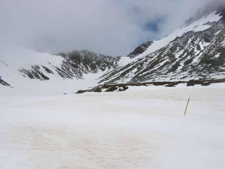
A circa 2450 m, lo si abbandona piegando a sinistra per i dolci prati solcati da qualche rigagnolo derivante da sorgenti, portandosi in un modesto impluvio proveniente dalla verticale della Tete Rouge, riconoscibile dal colore rossastro (per via dell’erba secca a fine stagione); più a sinistra la vasta pietraia sotto la Tete Verte, il cui colore è invece derivato dai licheni che le ricoprono.
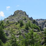
Si sale nell’impluvio su terreno non impervio, finchè sulla sinistra si arriva all’altezza di un dosso, alla base della pietraia della Tete Verte. Si traversa per portarsi sul modesto ripiano a monte del dosso, e quindi aggirando verso sinistra l’estesa pietraia si riprende a salire con buona pendenza sfruttando le lingue detritiche meno accidentate, che senza alcuna difficoltà portano praticamente sotto la cima della Tete Verte 2856 m.
Per toccare anche la più modesta sommità della Tete Rouge, si percorre il facile crestone costituito spesso da blocchi di pietra verso nord, restando talvolta qualche metro sul versante Menouve. Dopo aver superato un’anticima della Tete Verte, si arriva ad una selletta ormai a poca distanza dalla Tete Rouge 2805 m.
La via di discesa più comoda è quella di ripercorrere il percorso dell’andata, altrimenti si possono scendere i pendii piuttosto ripidi ma erbosi sotto la cima; altra soluzione ancora è provare a raggiungere per cresta, attraversando zone più ripide, il colle sud de Menouve 2754 m, da cui un antico sentiero si ricollega a quello per il colle nord a circa 2650 m.
- Cartografia:
- I.G.C. 1:50000 n° 4 Monte Bianco
- Bibliografia:
- Guida C.A.I.-T.C.I. Alpi Pennine 1°
Nelle vicinanze Mappa
Itinerari
29/06/2026 AO, Etroubles D+ 758 m E Varie
Paglietta (Mont) da Eternod, anello
 50m
50m
28/06/2025 AO, Etroubles D+ 1250 m EE Sud
Barasson (Pointe de) da Eternod per il Colle Est di Barasson
 50m
50m
27/09/2025 AO, Etroubles D+ 1062 m E Sud-Est
Noir (Bec) da Eternod per il Col Nord de Menouve
 50m
50m
22/08/2025 AO, Etroubles D+ 1050 m EE Sud-Est
Barasson (Tête de) da Eternod per il Colle Est di Barasson
 50m
50m
31/03/2026 AO, Etroubles D+ 500 m E Sud
Plan Puitz (Batterie di) da Eternod
 50m
50m
25/06/2023 AO, Etroubles D+ 1165 m E Nord
Grande Tête o Gran Testa da Etroubles
 1.4Km
1.4Km
26/02/2022 AO, Etroubles D+ 100 m E Varie
Via Francigena Tappa AO2: da Etroubles ad Aosta
 1.4Km
1.4Km
18/10/2025 AO, Etroubles D+ 1485 m EE Sud
Menouve (Mont de) da Prailles/Eternod per il Bivacco Molline
 1.5Km
1.5Km
17/06/2026 AO, Etroubles D+ 858 m E Sud
Molline (Bivacco) da Prailles
 1.5Km
1.5Km
18/10/2025 AO, Etroubles D+ 1403 m EE Sud-Est
Crete Seche (Pointe de) e Col Molline da Prailles/Eternod, anello
 1.5Km
1.5Km
Servizi
1.2Km
1.2Km
Guido Letey – Noleggio con Conducente Servizi
Etrobles 1.2Km
1.2Km
Chez Lugon – Bar e Tennis Ristorante
Étroubles
1.3Km
Mont Velan Albergo
Saint-Oyen 1.4Km
1.4Km
Maison Julie B&B
Etroubles 1.4Km
1.4Km
Château Verdun e Grange Neuve B&B
Saint-Oyen 1.5Km
1.5Km
Camping Tunnel International Campeggio
Etroubles 1.6Km
1.6Km
Brasserie du Saint-Bernard Ristorante
Saint-Oyen 1.6Km
1.6Km
Hotel Mont Velan Albergo
Saint-Oyen 1.7Km
1.7Km