 4.1Km
4.1Km


Note
Storico
 600m
2.1Km
2.3Km
2.3Km
2.3Km
2.3Km
2.3Km
2.3Km
2.3Km
600m
2.1Km
2.3Km
2.3Km
2.3Km
2.3Km
2.3Km
2.3Km
2.3Km
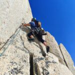
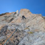
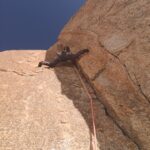
Via super, su granito tipico del bianco (ma quasi mai rosso), con soste a spit e anello di calata.
Sulla via sono presenti solo 8 spit dove non si può proprio proteggere, altrove si integra. Necessaria set di friend dallo 00 al 3, doppi dallo 02 al 1 e anche un friend n5 puó essere utile per le lunghezze 7 e 11
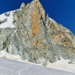
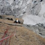
Avvicinamento
Sulla via sono presenti solo 8 spit dove non si può proprio proteggere, altrove si integra. Necessaria set di friend dallo 00 al 3, doppi dallo 02 al 1 e anche un friend n5 puó essere utile per le lunghezze 7 e 11
Due opzioni:
- Scendere verso la combe de la vierge facendo un giro (molto) largo da destra. E poi all’altezza dell’attacco traversare orizzontalmente verso sinistra faccia a valle fino all’attacco. Molto crepacciato e a fine stagione abbastanza difficile, anche se breve. 45/50 min
- andare al col flambeau e scendere di circa 250 m D+ e recarsi sulla cresta sud della vierge, una volta in punta iniziare le doppie. 2h max doppie incluse e al ritorno non bisogna più farle. Accesso consigliato in questa stagione
Descrizione
- Scendere verso la combe de la vierge facendo un giro (molto) largo da destra. E poi all’altezza dell’attacco traversare orizzontalmente verso sinistra faccia a valle fino all’attacco. Molto crepacciato e a fine stagione abbastanza difficile, anche se breve. 45/50 min
- andare al col flambeau e scendere di circa 250 m D+ e recarsi sulla cresta sud della vierge, una volta in punta iniziare le doppie. 2h max doppie incluse e al ritorno non bisogna più farle. Accesso consigliato in questa stagione
- L1 6a 2 spit
- L2 6b+ molto fisico su fessure perfette
- L3 6a+ sulle stesse fessure più appoggiato
- L4 trasferimento
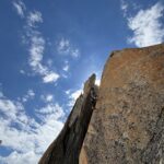
- L5 6b+ passo di placca e poi leggermente verso sinistra seguendo i 3 spit
- L6 7a lunghezza majeur bellissimo diedro 1 spit
- L7 6b prima a destra poi infilarsi nel diedro e poi uscire leggermente a sinistra
- L8 trasferimento
- L9 6c fessura bella poi placca (2 spit)
- L10 trasferimento
- L11 6b+ fessura di incastro poi traverso su cengia strettissima in leggera salita poi off width finale. Se non si è avvezzi allo stile, tiro duro
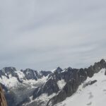
In base all’approccio fatto, fare le doppie e tornare a piedi o uscire sulla cresta e ritornare al flambeau.
Giugno 2025 - Heike schmitt. Philip Babicz
Nelle vicinanze Mappa
Itinerari
19/07/2026 Haute-Savoie, Chamonix-Mont-Blanc 5a, 4 obbl. Nord
Petit Flambeau – Via Laurent Grivel
 600m
600m
27/12/2022 AO, Courmayeur 6a+, 5a obbl., a0 Nord-Ovest
Marbrées (Aiguilles) – Trabaldo
1.9Km
17/07/2024 Haute-Savoie, Chamonix-Mont-Blanc 6b+, 6a+ obbl. Nord-Est
Tour Ronde – Via Cheraz
 2.1Km
2.1Km
04/07/2026 Haute-Savoie, Chamonix-Mont-Blanc 6a, 5c obbl. Est
Adolphe Rey (Pic) – Super Lionel
 2.3Km
2.3Km
23/06/2026 Haute-Savoie, Chamonix-Mont-Blanc 7a, 6b obbl. Est
Adolphe Rey (Pic) – Fil ou Face
 2.3Km
2.3Km
21/06/2026 Haute-Savoie, Chamonix-Mont-Blanc 6a+, 5c obbl. Est
Adolphe Rey (Pic) – Via Salluard
 2.3Km
2.3Km
10/07/2026 Haute-Savoie, Chamonix-Mont-Blanc 6c+, 6b obbl. Sud-Est
Adolphe Rey (Pic) – Cache Cache
 2.3Km
2.3Km
15/06/2026 Haute-Savoie, Chamonix-Mont-Blanc 6b+, 6a obbl. Sud
Adolphe Rey (Pic) – Via Bettembourg
 2.3Km
2.3Km
12/07/2026 Haute-Savoie, Chamonix-Mont-Blanc 7a+, 6b obbl. Sud-Est
Adolphe Rey (Pic) – Coup de Foudre
 2.3Km
2.3Km
27/08/2016 Haute-Savoie, Chamonix-Mont-Blanc 7a, 6a obbl. Sud-Est
Adolphe Rey (Pic) – Total Plook
 2.3Km
2.3Km
