 3.7Km
3.7Km

Note
 1.3Km
3.8Km
4.3Km
4.4Km
4.7Km
1.3Km
3.8Km
4.3Km
4.4Km
4.7Km
3.7Km
4.1Km
6.5Km
6.7Km
6.7Km
6.7Km
6.8Km
6.8Km
6.8Km
6.8Km
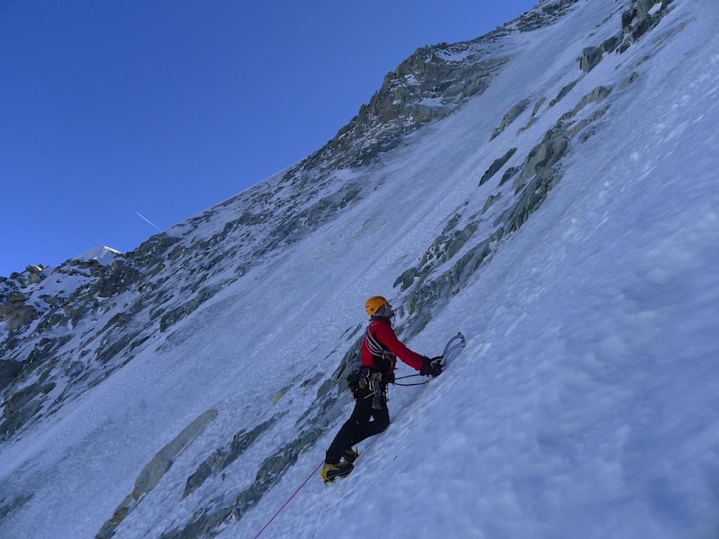
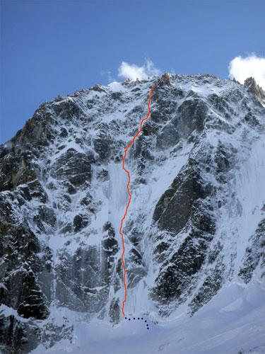
Passata la terminale si sale 100m di pendio a 50° fino all'inizio ddelle evidenti goulotte le piu a sinistra.a destra sale la charlet classica.
Con sei tiri di corda con brevi tratti a 85° si superano le belle goulotte della variante per poi ricobgiungersi alla via classica che con altri 5-6 porta al colle.
Discesa su soste attrezzate corde da 60m obbligatorie.
Avvicinamento
Con sei tiri di corda con brevi tratti a 85° si superano le belle goulotte della variante per poi ricobgiungersi alla via classica che con altri 5-6 porta al colle.
Discesa su soste attrezzate corde da 60m obbligatorie.
Dal paese Argentiere in funivia ai grandes montet poi al rif argentiere.
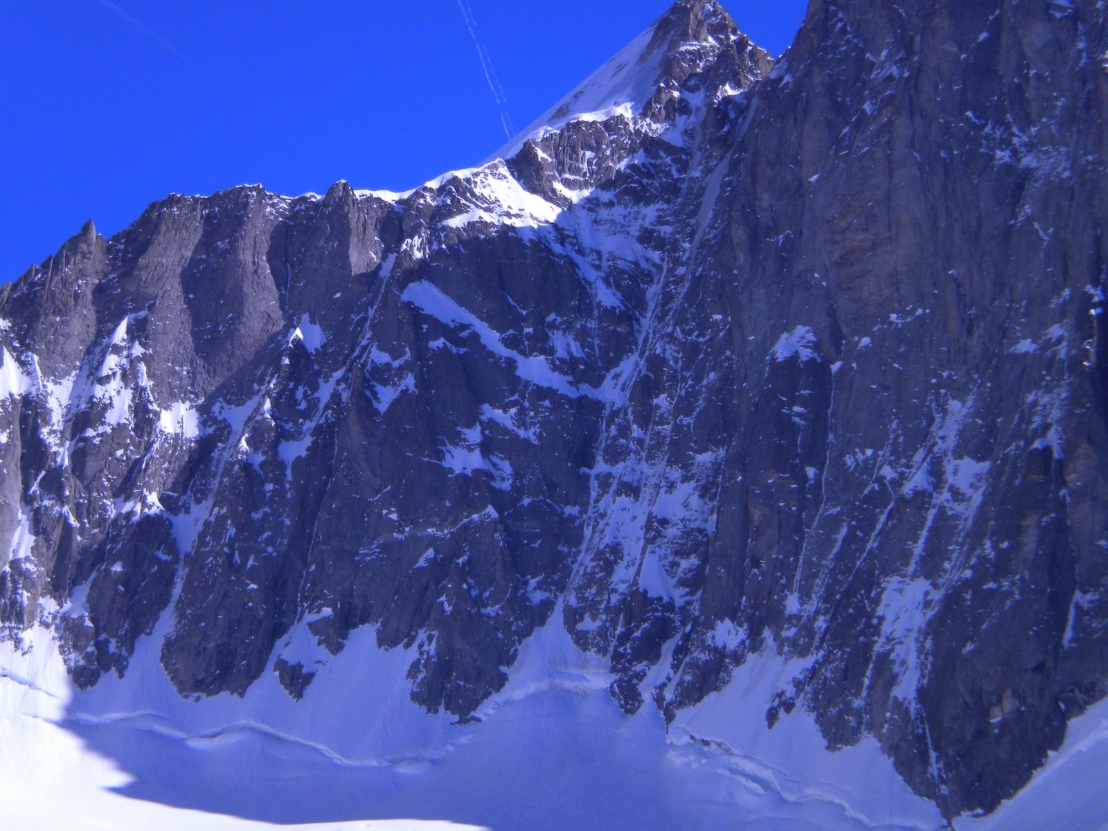
Si risale il ghiacciaio fino alla teeminale dove inizia la via proprio dritta sotto la vetta del mont dolent.
Descrizione
Si risale il ghiacciaio fino alla teeminale dove inizia la via proprio dritta sotto la vetta del mont dolent.
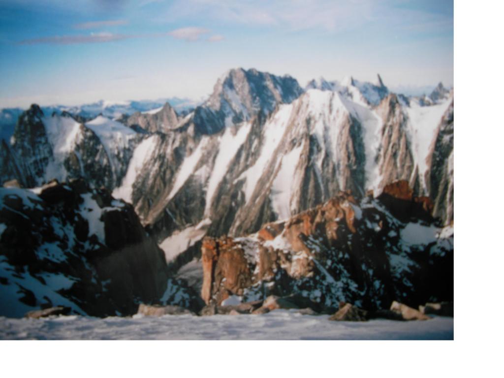
Bellissima via su una delle 5 grandi nord dell Argentiere.
Nelle vicinanze Mappa
Itinerari
11/05/2015 Haute-Savoie, Chamonix-Mont-Blanc D+ 500 m TD Varie
Pre de Bar (Pointe) – Goulotte Madness Tres Mince
350m
07/03/2025 Haute-Savoie, Chamonix-Mont-Blanc D+ 900 m TD Nord-Ovest
Domino (Pointe du) Petit Viking
 1.3Km
1.3Km
25/04/2018 Haute-Savoie, Chamonix-Mont-Blanc D+ 850 m D Nord
Courtes (les) Voie des Autrichiens
3.7Km
11/04/2026 Haute-Savoie, Chamonix-Mont-Blanc D+ 800 m TD Nord
Courtes (Les) Voie des Suisses
 3.8Km
3.8Km
31/07/2012 Haute-Savoie, Chamonix-Mont-Blanc D+ 1400 m D Sud
Argentière (Aiguille d’) Arete du Jardin
4.1Km
04/07/2022 Haute-Savoie, Chamonix-Mont-Blanc D+ 300 m TD Sud-Est
Minaret (le), Sperone SE – Via Mazars-Rébuffat
 4.3Km
4.3Km
14/03/2012 Haute-Savoie, Chamonix-Mont-Blanc D+ 1200 m PD+ Sud-Ovest
Argentiere (Aiguille d’) via normale dal Ghiacciao del Milieu
 4.4Km
4.4Km
17/08/2019 Haute-Savoie, Chamonix-Mont-Blanc D+ 286 m D Sud
Refuge (Aiguille du) – Gateau de Riz
4.4Km
22/07/2021 Haute-Savoie, Chamonix-Mont-Blanc D+ 388 m D Sud
Genepy (Aiguille du) Arete du Genepy
4.5Km
12/04/2015 Haute-Savoie, Chamonix-Mont-Blanc D+ 1300 m ED- Nord
Droites (Les) Ginat
 4.7Km
4.7Km
Servizi
3.7Km
4.1Km
Cabane de l’A Neuve Rifugio
La Fouly 6.5Km
6.5Km
Chalet le Dolent B&B
La Fouly
6.7Km
Cabane de Saleinaz Rifugio
Praz-de-Fort 6.7Km
6.7Km
Auberge de Maya Joie Albergo
La Fouly 6.7Km
6.7Km
Majya-Joie Ristorante
La Fouly 6.8Km
6.8Km
Edelweiss Ristorante
La Fouly 6.8Km
6.8Km
Hotel Edelweiss Albergo
La Fouly 6.8Km
6.8Km
Zanskar Sport Servizi
La Fouly 6.8Km
6.8Km