 7.1Km
7.1Km
Avvicinamento
 50m
3Km
3.3Km
4.6Km
5.4Km
50m
3Km
3.3Km
4.6Km
5.4Km
7.1Km
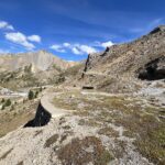
Da Torino: SS24 del Monginevro oppure A32 uscita Oulx Circonvallazione, si raggiunge Cesana Torinese e si sale al Colle del Monginevro. Discesa fino a Briançon dove nel centro del paese si seguono le indicazioni per il Col de l'Izoard. Raggiunto il colle si scende per 3 km verso Arvieux fino a raggiungere il Col de la Platriere 2220 m (posteggio della Casse Deserte).
Da Cuneo: risalire la Valle Varaita sconfinando in Francia attraverso il Colle dell'Agnello. Scendere verso Guillestre fino ad incontrare a destra il bivio per il Col de l'Izoard. Si supera Arvieux e si giunge al posteggio della Casse Deserte.
Descrizione
Da Cuneo: risalire la Valle Varaita sconfinando in Francia attraverso il Colle dell'Agnello. Scendere verso Guillestre fino ad incontrare a destra il bivio per il Col de l'Izoard. Si supera Arvieux e si giunge al posteggio della Casse Deserte.
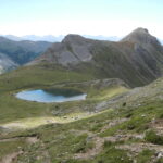
Dal Col de la Platriere (posteggio della Casse Deserte) si segue il bellissimo sentiero che dolcemente sale nel bosco di pini cembri, per poi entrare nel valloncello erboso che raggiunge dopo circa 2.5 km il Lac de Souliers 2492 m, preannunciato da una grossa croce di legno posta su un colletto poco prima del lago.
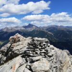
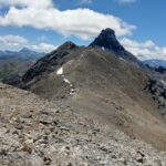
Dal lago una evidentissima traccia risale verso sud raggiungendo il crestone, leggermente più stretto negli ultimi metri ma senza difficoltà.
Discesa per l’itinerario di salita.
- Cartografia:
- IGN 3537 OT
Ultima revisione 08/05/2026
Nelle vicinanze Mappa
Itinerari
22/09/2024 Hautes-Alpes, Arvieux D+ 732 m EE Sud
Cote Belle (Pic Ouest de) dal Col de la Platriere per il Lac de Souliers
 50m
50m
11/07/2010 Hautes-Alpes, Cervières D+ 671 m E Sud
Grand Peygu dagli Chalets de l’Izoard
3Km
20/09/2025 Hautes-Alpes, Cervières D+ 610 m EE Varie
Cime (Clot de la) dagli Chalets de l’Izoard, anello per il Col des Ourdeis e il Col de l’Izoard
 3Km
3Km
30/07/2023 Hautes-Alpes, Arvieux D+ 900 m EE Varie
Maravoise (Pic de) da Brunissard
 3.3Km
3.3Km
01/09/2007 Hautes-Alpes, Arvieux D+ 1000 m EE Varie
Esparges Fines (Pic des) da le Coin d’Arvieux
4Km
29/07/2023 Hautes-Alpes, Arvieux D+ 1000 m E Varie
Barre Noire da Arvieux, anello per il Col de Fountouse
 4.6Km
4.6Km
09/08/2013 Hautes-Alpes, Cervières D+ 1320 m EE Nord-Ovest
Turge de la Suffie da le Laus
5.4Km
08/07/2025 Hautes-Alpes, Cervières D+ 1280 m EE Nord-Est
Escalinade (l’) e Turge de la Suffie da les Chalps per il Lac des Cordes, anello per il Col de Marsailles
 5.4Km
5.4Km
29/07/2015 Hautes-Alpes, Cervières D+ 900 m EE Tutte
Peygus (Col des) da le Laus, anello
5.4Km
11/08/2013 Hautes-Alpes, Arvieux D+ 700 m E Nord
Gazon (Pic du) da Chalets du Vallon
6.5Km
Servizi
7.1Km